Corregidor
Airport details
| Country | Philippines |
| State | Cavite |
| Region | |
| Airspace | Manila Ctr |
| Municipality | Cavite City |
| Elevation | 102ft (31m) |
| Timezone | GMT +8 |
| Coordinates | 14.39135, 120.60538 |
| Magnetic var | |
| Type | land |
| Available since | X-Plane v10.40 |
| ICAO code | RPLX |
| IATA code | n/a |
| FAA code | n/a |
Communication
| Corregidor CTAF | 121.900 |
Nearby Points of Interest:
Tanza Church
-Abucay Church
-National Museum of Fine Arts
-Gota de Leche Building
-Santa Ana Heritage Zone
-Lubao Church
-Mount Makiling
-Lazatin House
-Henson-Hizon House
-Augusto P. Hizon House
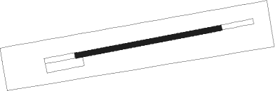
Runway info
| Runway 09 / 27 | ||
| length | 422m (1385ft) | |
| bearing | 84° / 264° | |
| width | 15m (50ft) | |
| surface | grass | |
Nearby beacons
| code | identifier | dist | bearing | frequency |
|---|---|---|---|---|
| MIA | MANILA VOR/DME | 25.2 | 74° | 114.40 |
| SBA | SUBIC BAY VOR/DME | 31.6 | 315° | 113.50 |
| CIA | CLARK VOR/DME | 47.8 | 357° | 113.10 |
Disclaimer
The information on this website is not for real aviation. Use this data with the X-Plane flight simulator only! Data taken with kind consent from X-Plane 12 source code and data files. Content is subject to change without notice.