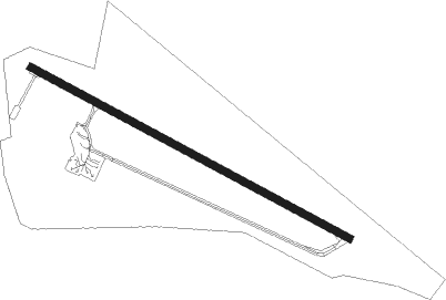
Mar Del Plata - Astor Piazzolla
Airport details
| Country | Argentina |
| State | Buenos Aires |
| Region | SA |
| Airspace | Ezeiza Ctr |
| Municipality | Mar del Plata |
| Elevation | 69ft (21m) |
| Timezone | GMT -3 |
| Coordinates | -37.93417, -57.57333 |
| Magnetic var | |
| Type | land |
| Available since | X-Plane v10.32 |
| ICAO code | SAZM |
| IATA code | MDQ |
| FAA code | n/a |
Communication
| Astor Piazzolla Ground Control | 121.700 |
| Astor Piazzolla Tower | 118.750 |
| Astor Piazzolla Approach | 118.750 |
| Astor Piazzolla Departure | 118.750 |
Approach frequencies
| ILS-cat-I | RW13 | 109.5 | 18.00mi |
| 3° GS | RW13 | 109.5 | 18.00mi |
Nearby beacons
| code | identifier | dist | bearing | frequency |
|---|---|---|---|---|
| MDP | MAR DEL PLATA VOR/DME | 0.2 | 324° | 116.20 |
| GES | VILLA GESSELL NDB | 49.4 | 38° | 242 |
Departure and arrival routes
| Transition altitude | 3000ft |
| SID end points | distance | outbound heading | |
|---|---|---|---|
| RW13 | |||
| ROPI1D, ROPI1C | 77mi | 27° | |
| ROGA1C | 30mi | 240° | |
| SIRA1C | 30mi | 260° | |
| ESUR1C | 30mi | 293° | |
| PULP1D, PULP1C | 57mi | 353° | |
| RW31 | |||
| ROPI1G | 77mi | 27° | |
| ROGA1G | 30mi | 240° | |
| SIRA1G | 30mi | 260° | |
| ESUR1G | 30mi | 293° | |
| PULP1G | 57mi | 353° | |
| STAR starting points | distance | inbound heading | |
|---|---|---|---|
| RW13 | |||
| ROGA1Q | 29.9 | 60° | |
| SIRA1Q | 30.1 | 80° | |
| ESUR1Q | 30.2 | 113° | |
| VOTR1Q | 56.6 | 152° | |
| MUDN1Q | 72.7 | 197° | |
| ROPI1Q, ROPI1R | 77.4 | 207° | |
| RW31 | |||
| ROGA1U | 29.9 | 60° | |
| SIRA1U | 30.1 | 80° | |
| ESUR1U | 30.2 | 113° | |
| VOTR1U | 56.6 | 152° | |
| MUDN1U | 72.7 | 197° | |
| ROPI1U | 77.4 | 207° | |
Instrument approach procedures
| runway | airway (heading) | route (dist, bearing) |
|---|---|---|
| RW13 | AKROG (117°) | AKROG 3000ft KOVEX (6mi, 117°) 2300ft |
| RW13 | DALMI (140°) | DALMI 3000ft KOVEX (6mi, 196°) 2300ft |
| RW13 | PUNOX (97°) | PUNOX 3000ft KOVEX (6mi, 59°) 2300ft |
| RNAV | KOVEX 2300ft IVREK (5mi, 117°) 1700ft SAZM (6mi, 117°) 121ft ZM110 (4mi, 117°) PUMTO (12mi, 94°) 3000ft PUMTO (turn) 3000ft | |
| RW31 | GAVIK (328°) | GAVIK 3000ft SIRUR (6mi, 38°) 1700ft |
| RW31 | NIRSU (272°) | NIRSU 3000ft SIRUR (6mi, 221°) 1700ft |
| RNAV | SIRUR 1700ft TENOV (4mi, 297°) 1700ft SAZM (6mi, 297°) 112ft AKROG (17mi, 297°) 3000ft AKROG (turn) 3000ft |
Holding patterns
| STAR name | hold at | type | turn | heading* | altitude | leg | speed limit |
|---|---|---|---|---|---|---|---|
| ESUR1Q | ESURO | VHF | right | 300 (120)° | DME 4.0mi | 210 | |
| ESUR1U | ESURO | VHF | right | 300 (120)° | DME 4.0mi | 210 | |
| SIRA1Q | SIRAN | VHF | right | 248 (68)° | DME 4.0mi | 210 | |
| SIRA1U | SIRAN | VHF | right | 248 (68)° | DME 4.0mi | 210 | |
| VOTR1Q | VOTRA | VHF | right | 358 (178)° | DME 7.0mi | 240 | |
| VOTR1U | VOTRA | VHF | right | 358 (178)° | DME 7.0mi | 240 | |
| *) magnetic outbound (inbound) holding course | |||||||
Disclaimer
The information on this website is not for real aviation. Use this data with the X-Plane flight simulator only! Data taken with kind consent from X-Plane 12 source code and data files. Content is subject to change without notice.
