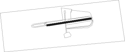
Melipilla
Airport details
| Country | Chile |
| State | Santiago Metropolitan Region |
| Region | SC |
| Airspace | Santiago Ctr |
| Municipality | Melipilla |
| Elevation | 586ft (179m) |
| Timezone | GMT -3 |
| Coordinates | -33.67389, -71.19361 |
| Magnetic var | |
| Type | land |
| Available since | X-Plane v10.40 |
| ICAO code | SCMP |
| IATA code | n/a |
| FAA code | n/a |
Communication
Runway info
| Runway 08 / 26 | ||
| length | 531m (1742ft) | |
| bearing | 86° / 266° | |
| width | 20m (66ft) | |
| surface | dry lakebed | |
Nearby beacons
| code | identifier | dist | bearing | frequency |
|---|---|---|---|---|
| SNO | SANTO DOMINGO NDB | 20.9 | 273° | 355 |
| DGO | DOMINGO VOR/DME | 21 | 272° | 112.30 |
| PDH | PUDAHUEL (SANTIAGO) VOR/DME | 25 | 57° | 117.20 |
| AMB | SANTIAGO VOR/DME | 25.5 | 58° | 116.10 |
| BQE | EL BOSQUE VOR/DME | 25.9 | 78° | 117.50 |
| SAL | SALINAS NDB | 44.7 | 334° | 390 |
| VDM | VINA DEL MAR VOR/DME | 45.9 | 339° | 114.90 |
| TBN | TABON VOR/DME | 48.7 | 25° | 113.90 |
| VTN | VENTANAS VOR/DME | 58.1 | 342° | 113.30 |
Disclaimer
The information on this website is not for real aviation. Use this data with the X-Plane flight simulator only! Data taken with kind consent from X-Plane 12 source code and data files. Content is subject to change without notice.
