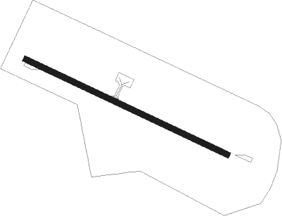
Puerto Natales - Teniente Julio Gallardo
Airport details
| Country | Chile |
| State | Region of Magallanes and Chilean Antarct |
| Region | SC |
| Airspace | Punta Arenas Ctr |
| Municipality | Puerto Natales |
| Elevation | 214ft (65m) |
| Timezone | GMT -4 |
| Coordinates | -51.67083, -72.52861 |
| Magnetic var | |
| Type | land |
| Available since | X-Plane v10.40 |
| ICAO code | SCNT |
| IATA code | PNT |
| FAA code | n/a |
Communication
| Teniente Julio Gallardo NATALES INFO | 127.700 |
Nearby beacons
| code | identifier | dist | bearing | frequency |
|---|---|---|---|---|
| PNT | PUERTO NATALES VOR/DME | 4.8 | 129° | 115.90 |
| BIO | EL TURBIO NDB | 12 | 79° | 205 |
Departure and arrival routes
| Transition altitude | 3500ft |
| SID end points | distance | outbound heading | |
|---|---|---|---|
| RW10 | |||
| NEDA3B | 31mi | 129° | |
| KOLP2B, KOLP2D | 97mi | 311° | |
| RW28 | |||
| NEDA2H, NEDA3A | 31mi | 129° | |
| KOLP2A, KOLP2C | 97mi | 311° | |
| STAR starting points | distance | inbound heading | |
|---|---|---|---|
| RW28 | |||
| BODO2A | 91.2 | 136° | |
| SIRUN2 | 36.5 | 323° | |
Instrument approach procedures
| runway | airway (heading) | route (dist, bearing) |
|---|---|---|
| RW10 | NEPOL (136°) | NEPOL UGAPO (17mi, 135°) NT408 (6mi, 120°) NT346 (6mi, 119°) 9000ft NT285 (6mi, 119°) 7500ft NT207 (7mi, 175°) 5500ft AKNIV (7mi, 269°) 3500ft |
| RW10 | SIRUN (323°) | SIRUN 7000ft MUDAS (23mi, 323°) 5500ft AKNIV (9mi, 301°) 3500ft |
| RNAV | AKNIV 3500ft EGAPA (5mi, 303°) 2700ft NT015 (4mi, 51°) 750ft SCNT (2mi, 110°) 259ft (4761mi, 55°) 700ft MUDAS (4758mi, 234°) 3500ft MUDAS (turn) 3500ft | |
| RW28-Z | NEPOL (136°) | NEPOL UGAPO (17mi, 135°) NT450 (9mi, 163°) 10000ft NT361 (9mi, 163°) 8000ft NT273 (9mi, 163°) 6000ft MUDAS (8mi, 88°) 3500ft |
| RW28-Z | SIRUN (323°) | SIRUN 7000ft NT267 (11mi, 322°) 6000ft MUDAS (11mi, 323°) 3500ft |
| RNAV | MUDAS 3500ft NT086 (7mi, 10°) 2500ft DAKAN (3mi, 320°) 2000ft SCNT (6mi, 289°) 268ft (4761mi, 55°) 700ft MUDAS (4758mi, 234°) 3500ft MUDAS (turn) 3500ft | |
| RW28 | MUDAS (323°) | MUDAS 3500ft NT118 (6mi, 53°) 2300ft |
| RW28 | TEKIS (302°) | TEKIS 3500ft NT118 (5mi, 319°) 2300ft |
| RNAV | NT118 2300ft KOMPO (7mi, 297°) 1800ft NT008 (4mi, 297°) 523ft TEKIS (16mi, 123°) 3500ft TEKIS (turn) 3500ft |
Holding patterns
| STAR name | hold at | type | turn | heading* | altitude | leg | speed limit |
|---|---|---|---|---|---|---|---|
| BODO2A | MUDAS | VHF | left | 206 (26)° | DME 4.0mi | ICAO rules | |
| SIRUN2 | TEKIS | VHF | left | 138 (318)° | DME 4.0mi | ICAO rules | |
| *) magnetic outbound (inbound) holding course | |||||||
Disclaimer
The information on this website is not for real aviation. Use this data with the X-Plane flight simulator only! Data taken with kind consent from X-Plane 12 source code and data files. Content is subject to change without notice.
