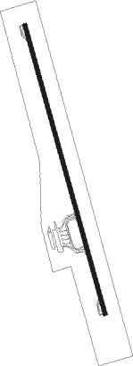
Yampareaz - Alcantari Intl
Airport details
| Country | Bolivia |
| State | Chuquisaca |
| Region | SL |
| Airspace | La Paz Ctr |
| Municipality | Municipio Yamparaez |
| Elevation | 10184ft (3104m) |
| Timezone | GMT -4 |
| Coordinates | -19.23883, -65.14908 |
| Magnetic var | |
| Type | land |
| Available since | X-Plane v10.30 |
| ICAO code | SLAL |
| IATA code | SRE |
| FAA code | n/a |
Communication
Approach frequencies
| ILS-cat-I | RW36 | 109.9 | 18.00mi |
| 3.3° GS | RW36 | 109.9 | 18.00mi |
Nearby Points of Interest:
Palacio de la Prefectura de Chuquisaca
-Sucre
-Cal Orcko
Runway info
| Runway 18 / 36 | ||
| length | 3615m (11860ft) | |
| bearing | 168° / 348° | |
| width | 47m (154ft) | |
| surface | asphalt | |
| blast zone | 43m (141ft) / 43m (141ft) | |
Nearby beacons
| code | identifier | dist | bearing | frequency |
|---|---|---|---|---|
| ALC | ALCANTARI VOR/DME | 1.7 | 168° | 113.40 |
| SUR | SUCRE VOR/DME | 15.8 | 328° | 116.50 |
| PTS | POTOSI VOR/DME | 35.2 | 242° | 114.90 |
Instrument approach procedures
| runway | airway (heading) | route (dist, bearing) |
|---|---|---|
| RW36-Z | AL427 (315°) | AL427 16000ft AL426 (7mi, 259°) 13700ft |
| RW36-Z | AL428 (22°) | AL428 16000ft AL426 (7mi, 79°) 13700ft |
| RW36-Z | AL429 (348°) | AL429 16000ft AL426 (7mi, 348°) 13700ft |
| RNAV | AL426 13700ft AL424 (5mi, 348°) 11980ft AL423 (3mi, 348°) 10926ft EGLAP (26mi, 348°) 15000ft EGLAP (turn) 15000ft |
Disclaimer
The information on this website is not for real aviation. Use this data with the X-Plane flight simulator only! Data taken with kind consent from X-Plane 12 source code and data files. Content is subject to change without notice.
