Peruibe - Peruibe Ilha Clube Aerodesportivo
Airport details
| Country | Brazil |
| State | São Paulo |
| Region | |
| Airspace | Curitiba Ctr |
| Municipality | Peruíbe |
| Elevation | 48ft (15m) |
| Timezone | GMT -3 |
| Coordinates | -24.31884, -47.01324 |
| Magnetic var | |
| Type | land |
| Available since | X-Plane v10.40 |
| ICAO code | SSMW |
| IATA code | n/a |
| FAA code | n/a |
Communication
| Peruibe Ilha Clube Aerodesportivo RDO | 123.450 |
Nearby Points of Interest:
Juréia-Itatins Ecological Station
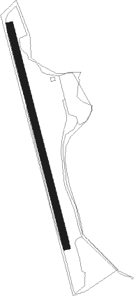
Runway info
| Runway 01 / 19 | ||
| length | 600m (1969ft) | |
| bearing | 349° / 169° | |
| width | 18m (59ft) | |
| surface | grass | |
Nearby beacons
| code | identifier | dist | bearing | frequency |
|---|---|---|---|---|
| EMB | EMBUGUACU (SAO PAULO) NDB | 30.1 | 23° | 525 |
| RDE | REDE (SAO PAULO) VOR/DME | 36.9 | 49° | 116.70 |
| DAD | DIADEMA (SAO PAULO) NDB | 43.2 | 34° | 200 |
| CGO | CONGONHAS (SAO PAULO) VOR/DME | 45.9 | 27° | 116.90 |
| RGI | DME | 47 | 256° | 113 |
| STN | SANTANA (SAO PAULO TMA) VOR/DME | 50.1 | 6° | 114.30 |
| SCB | SOROCABA (SAO PAULO TMA) VOR/DME | 52.7 | 336° | 115.20 |
| IG | TUCA (SAO PAULO) NDB | 56.8 | 27° | 410 |
| BCO | BONSUCESSO (SAO PAULO) VOR/DME | 64.7 | 35° | 116 |
Disclaimer
The information on this website is not for real aviation. Use this data with the X-Plane flight simulator only! Data taken with kind consent from X-Plane 12 source code and data files. Content is subject to change without notice.