Santa Barbara Del Zulia
Airport details
| Country | Venezuela |
| State | Zulia State |
| Region | SV |
| Airspace | Maiquetia Ctr |
| Municipality | Parroquia Santa Bárbara |
| Elevation | 32ft (10m) |
| Timezone | GMT -4 |
| Coordinates | 8.97417, -71.94305 |
| Magnetic var | |
| Type | land |
| Available since | X-Plane v10.40 |
| ICAO code | SVSZ |
| IATA code | STB |
| FAA code | n/a |
Communication
| Santa Barbara del Zulia ATIS | 122.400 |
| Santa Barbara del Zulia Ground Control | 121.900 |
| Santa Barbara del Zulia Tower | 118.200 |
Nearby Points of Interest:
Juan Pablo Pérez Alfonso Airport
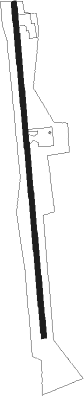
Runway info
| Runway 01 / 19 | ||
| length | 2708m (8885ft) | |
| bearing | 359° / 179° | |
| width | 40m (130ft) | |
| surface | asphalt | |
| displ threshold | 0m (0ft) / 80m (262ft) | |
Nearby beacons
| code | identifier | dist | bearing | frequency |
|---|---|---|---|---|
| STB | SANTA BARBARA DEL ZULIA VOR/DME | 0.4 | 23° | 114.90 |
| EVG | EL VIGIA VOR/DME | 26.3 | 143° | 116.80 |
| EVG | EL VIGIA NDB | 26.8 | 142° | 393 |
| LFA | LA FRIA VOR/DME | 48 | 204° | 113 |
| CU | CUCUTA NDB | 67.8 | 214° | 395 |
Disclaimer
The information on this website is not for real aviation. Use this data with the X-Plane flight simulator only! Data taken with kind consent from X-Plane 12 source code and data files. Content is subject to change without notice.