Anápolis - Anapolis
Airport details
| Country | Brazil |
| State | Goiás |
| Region | SB |
| Airspace | Brasilia Ctr |
| Municipality | Anápolis |
| Elevation | 3642ft (1110m) |
| Timezone | GMT -3 |
| Coordinates | -16.36250, -48.92805 |
| Magnetic var | |
| Type | land |
| Available since | X-Plane v10.32 |
| ICAO code | SWNS |
| IATA code | APS |
| FAA code | n/a |
Communication
| ANAPOLIS CTAF Anapolis | 123.450 |
Nearby Points of Interest:
House of the Babilónia Estate
-Praça Cívica
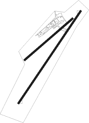
Runway info
Runway 06 / 24  | ||
| length | 2680m (8793ft) | |
| bearing | 40° / 220° | |
| width | 45m (148ft) | |
| surface | asphalt | |
| Runway 07 / 25 | ||
| length | 1520m (4987ft) | |
| bearing | 55° / 235° | |
| width | 45m (148ft) | |
| surface | asphalt | |
| displ threshold | 0m (0ft) / 259m (850ft) | |
Nearby beacons
| code | identifier | dist | bearing | frequency |
|---|---|---|---|---|
| APO | ANAPOLIS VOR/DME | 7.6 | 336° | 116.80 |
| GNV | GOIANIA VOR/DME | 23.3 | 225° | 115.90 |
| SBG | SANTA BARBARA (ANAPOLIS) NDB | 46.2 | 254° | 230 |
| LUZ | LUZIANIA VOR/DME | 55.5 | 84° | 113.10 |
| BSI | BRASILIA VOR/DME | 60 | 62° | 116.30 |
Disclaimer
The information on this website is not for real aviation. Use this data with the X-Plane flight simulator only! Data taken with kind consent from X-Plane 12 source code and data files. Content is subject to change without notice.