Dimmitt - Dimmitt Muni
Airport details
| Country | United States of America |
| State | Texas |
| Region | K4 |
| Airspace | Albuquerque Ctr |
| Municipality | Castro County |
| Elevation | 3881ft (1183m) |
| Timezone | GMT -6 |
| Coordinates | 34.56673, -102.32269 |
| Magnetic var | |
| Type | land |
| Available since | X-Plane v10.40 |
| ICAO code | T55 |
| IATA code | n/a |
| FAA code | T55 |
Communication
| Dimmitt Muni CTAF | 122.900 |
Nearby Points of Interest:
Buffalo Lake National Wildlife Refuge
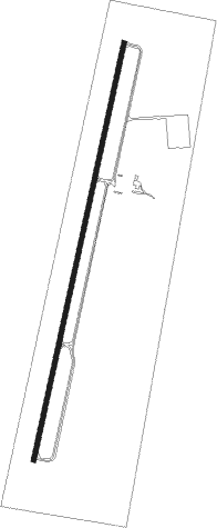
Runway info
| Runway 1 / 19 | ||
| length | 1679m (5509ft) | |
| bearing | 20° / 200° | |
| width | 18m (60ft) | |
| surface | asphalt | |
Nearby beacons
| code | identifier | dist | bearing | frequency |
|---|---|---|---|---|
| TXO | TEXICO VORTAC | 25.9 | 262° | 112.20 |
| PVW | PLAINVIEW VOR/DME | 39.1 | 132° | 112.90 |
| AM | PANDE (AMARILLO) NDB | 43.1 | 42° | 251 |
| CV | HISAN (CLOVIS) NDB | 44.1 | 256° | 335 |
| PNH | PANHANDLE VORTAC | 50.5 | 43° | 116.60 |
| CVS | CANNON (CLOVIS) TACAN | 50.7 | 259° | 111.60 |
| LBB | LUBBOCK VORTAC | 55.6 | 155° | 109.20 |
| LD | LUBBI (LUBBOCK) NDB | 61.9 | 146° | 272 |
Disclaimer
The information on this website is not for real aviation. Use this data with the X-Plane flight simulator only! Data taken with kind consent from X-Plane 12 source code and data files. Content is subject to change without notice.