Bequia - Bequia/j F Mitchell
Airport details
| Country | Saint Vincent and the Grenadines |
| State | Grenadines |
| Region | TV |
| Airspace | Piarco Ctr |
| Municipality | Bequia |
| Elevation | 14ft (4m) |
| Timezone | GMT -4 |
| Coordinates | 12.98694, -61.26445 |
| Magnetic var | |
| Type | land |
| Available since | X-Plane v10.40 |
| ICAO code | TVSB |
| IATA code | BQU |
| FAA code | n/a |
Communication
| Bequia/J F Mitchell Ground Control | 121.900 |
| Bequia/J F Mitchell Tower | 118.450 |
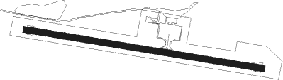
Runway info
| Runway 12 / 30 | ||
| length | 1099m (3606ft) | |
| bearing | 103° / 283° | |
| width | 30m (98ft) | |
| surface | asphalt | |
Nearby beacons
| code | identifier | dist | bearing | frequency |
|---|---|---|---|---|
| SV | ST VINCENT (SAINT VINCENT I) NDB | 9.4 | 14° | 403 |
| CAI | CANOUAN (ST. VINCENT) NDB | 18 | 194° | 302 |
| BNE | HEWANORRA (SAINT LUCIA) NDB | 47.8 | 21° | 305 |
| GND | MAURICE BISHOP(SAINT GEORGE'S) NDB | 66.1 | 208° | 362 |
| GND | MAURICE BISHOP(SAINT GEOR VOR/DME | 66.5 | 208° | 117.10 |
Disclaimer
The information on this website is not for real aviation. Use this data with the X-Plane flight simulator only! Data taken with kind consent from X-Plane 12 source code and data files. Content is subject to change without notice.