Corsicana - Smith
Airport details
| Country | United States of America |
| State | Texas |
| Region | |
| Airspace | Ft Worth Ctr |
| Municipality | Navarro County |
| Elevation | 403ft (123m) |
| Timezone | GMT -6 |
| Coordinates | 32.19422, -96.32584 |
| Magnetic var | |
| Type | land |
| Available since | X-Plane v10.40 |
| ICAO code | TX51 |
| IATA code | n/a |
| FAA code | TX51 |
Communication
Nearby Points of Interest:
Navarro County Courthouse
-Faulk and Gauntt Building
-William Lewis House
-Joshua Chapel A.M.E. Church
-Ellis County Courthouse
-West End Historic District
-Chautauqua Auditorium
-W. A. Strain Farm-Strain House
-Randlett House
-Matthew Cartwright House
-Warren-Crowell House
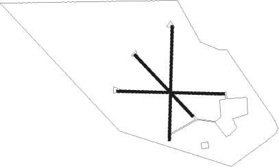
Runway info
Runway 18 / 36  | ||
| length | 671m (2201ft) | |
| bearing | 187° / 7° | |
| width | 15m (50ft) | |
| surface | grass | |
| Runway 09 / 27 | ||
| length | 633m (2077ft) | |
| bearing | 95° / 275° | |
| width | 15m (50ft) | |
| surface | grass | |
| Runway 14 / 32 | ||
| length | 494m (1621ft) | |
| bearing | 136° / 316° | |
| width | 15m (50ft) | |
| surface | grass | |
Nearby beacons
| code | identifier | dist | bearing | frequency |
|---|---|---|---|---|
| CQY | CEDAR CREEK VORTAC | 5.4 | 95° | 114.80 |
| CGQ | POWELL (CORSICANA) NDB | 9.3 | 218° | 344 |
| CRS | CORSICANA NDB | 10.5 | 203° | 396 |
| CSZ | CROSSROADS NDB | 20.3 | 110° | 215 |
| LXY | MEXIA NDB | 34.6 | 199° | 329 |
| PQF | MESQUITE NDB | 38.3 | 342° | 248 |
| GNL | GROESBECK (MEXIA) VOR/DME | 38.5 | 200° | 108.80 |
| FZT | FRANKSTON VOR/DME | 41 | 99° | 111.40 |
| TYR | TYLER VOR/DME | 47.8 | 80° | 114.20 |
| CVE | COWBOY (DALLAS) VOR/DME | 51 | 320° | 116.20 |
| MJF | ARVILLA (GREENVILLE) TACAN | 54 | 17° | 109.60 |
| TTT | MAVERICK VOR/DME | 54.3 | 313° | 113.10 |
| ROB | ROBINSON (WACO) NDB | 56.2 | 227° | 400 |
| ACT | WACO VORTAC | 57.7 | 241° | 115.30 |
| GV | MAJOR (GREENVILLE) NDB | 59.2 | 15° | 201 |
| FUZ | RANGER (DALLAS-FORT WORTH VORTAC | 60 | 309° | 115.70 |
| UIM | DME | 63.6 | 54° | 114 |
Disclaimer
The information on this website is not for real aviation. Use this data with the X-Plane flight simulator only! Data taken with kind consent from X-Plane 12 source code and data files. Content is subject to change without notice.