Chukotka - Provideniya Bay
Airport details
| Country | Russian Federation |
| State | Chukotka Autonomous Okrug |
| Region | UH |
| Municipality | Providensky urban district |
| Elevation | 69ft (21m) |
| Timezone | GMT +12 |
| Coordinates | 64.37805, -173.24333 |
| Magnetic var | |
| Type | land |
| Available since | X-Plane v10.40 |
| ICAO code | UHMD |
| IATA code | PVS |
| FAA code | n/a |
Communication
| Provideniya Bay Tower | 119.300 |
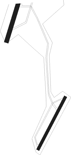
Runway info
Runway 03 / 21  | ||
| length | 1218m (3996ft) | |
| bearing | 55° / 235° | |
| width | 65m (213ft) | |
| surface | gravel | |
| Runway 01 / 19 | ||
| length | 2481m (8140ft) | |
| bearing | 42° / 222° | |
| width | 91m (299ft) | |
| surface | gravel | |
Nearby beacons
| code | identifier | dist | bearing | frequency |
|---|---|---|---|---|
| BC | PROVIDENIYA BAY NDB | 0 | 135° | 960 |
Disclaimer
The information on this website is not for real aviation. Use this data with the X-Plane flight simulator only! Data taken with kind consent from X-Plane 12 source code and data files. Content is subject to change without notice.