Uzhhorod - Uzhhorod Intl
Airport details
| Country | Ukraine |
| State | Zakarpattia Oblast |
| Region | UK |
| Airspace | Lviv Ctr |
| Municipality | Uzhhorod |
| Elevation | 381ft (116m) |
| Timezone | GMT +2 |
| Coordinates | 48.63445, 22.26333 |
| Magnetic var | |
| Type | land |
| Available since | X-Plane v10.40 |
| ICAO code | UKLU |
| IATA code | UDJ |
| FAA code | n/a |
Communication
| Uzhhorod Intl Tower | 134.500 |
| Uzhhorod Intl Approach | 121.900 |
Nearby Points of Interest:
Administration building in Uzhhorod
-Category:Reformed church in Tarnivtsi
-Exaltation of the Holy Cross church, Siurte
-Latorica Protected Landscape Area
-Wooden Greek Catholic church in Nová Paka
-Church of Saints Procopius and Barbara (Kunčice pod Ondřejníkem)
-Castle (Borša)
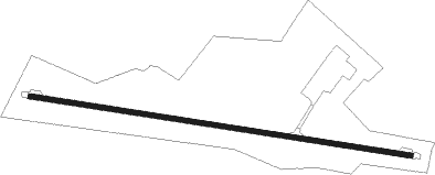
Runway info
| Runway 10 / 28 | ||
| length | 2030m (6660ft) | |
| bearing | 99° / 279° | |
| width | 25m (82ft) | |
| surface | asphalt | |
| displ threshold | 0m (0ft) / 635m (2083ft) | |
Nearby beacons
| code | identifier | dist | bearing | frequency |
|---|---|---|---|---|
| UO | UZHHOROD NDB | 0.1 | 234° | 645 |
| UZH | DME | 0.1 | 237° | 115.65 |
| SR | SEREDNIE NDB | 11.8 | 115° | 690 |
| VI | VERHNIE NDB | 35.9 | 69° | 334 |
| DUB | DME | 36.1 | 290° | 108.65 |
| PQ | NYIREGYHAZA NDB | 44.3 | 222° | 522 |
| NYR | NYIREGYHAZA VOR/DME | 44.8 | 222° | 116.10 |
| Y | NYIREGYHAZA 36 NDB | 46 | 221° | 346 |
| NY | NYIREGYHAZA 36 NDB | 49.1 | 219° | 330 |
| SAT | SATU MARE VOR/DME | 60 | 145° | 108.40 |
Departure and arrival routes
| Transition altitude | 10007ft |
| SID end points | distance | outbound heading | |
|---|---|---|---|
| RW28 | |||
| TAKO4A | 37mi | 96° | |
| RUMU4A | 56mi | 119° | |
| STAR starting points | distance | inbound heading | |
|---|---|---|---|
| RW10 | |||
| TAKO4F | 37.2 | 276° | |
| RUMU4F | 56.4 | 299° | |
| LONL4F | 17.8 | 349° | |
Holding patterns
| STAR name | hold at | type | turn | heading* | altitude | leg | speed limit |
|---|---|---|---|---|---|---|---|
| LONL4F | UO | FIX | right | 282 (102)° | > 2500ft | 1.0min timed | ICAO rules |
| RUMU4F | UO | FIX | right | 282 (102)° | > 2500ft | 1.0min timed | ICAO rules |
| TAKO4F | UO | FIX | right | 282 (102)° | > 2500ft | 1.0min timed | ICAO rules |
| VI4F | UO | FIX | right | 282 (102)° | > 2500ft | 1.0min timed | ICAO rules |
| *) magnetic outbound (inbound) holding course | |||||||
Disclaimer
The information on this website is not for real aviation. Use this data with the X-Plane flight simulator only! Data taken with kind consent from X-Plane 12 source code and data files. Content is subject to change without notice.