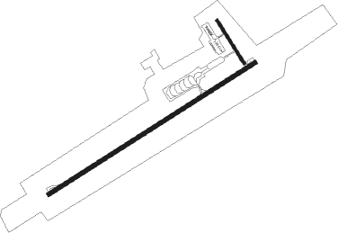
Vitebsk
Airport details
| Country | Belarus |
| State | Vitsebsk Region |
| Region | UM |
| Airspace | Minsk Ctr |
| Municipality | Акцябрскі сельскі Савет |
| Elevation | 683ft (208m) |
| Timezone | GMT +3 |
| Coordinates | 55.13526, 30.35973 |
| Magnetic var | |
| Type | land |
| Available since | X-Plane v10.40 |
| ICAO code | UMII |
| IATA code | VTB |
| FAA code | n/a |
Communication
| Vitebsk Approach | 124.000 |
| Vitebsk Approach | 120.400 |
Approach frequencies
| ILS-cat-I | RW23 | 111.9 | 18.00mi |
| 3° GS | RW23 | 111.9 | 18.00mi |
Nearby beacons
| code | identifier | dist | bearing | frequency |
|---|---|---|---|---|
| VTB | VICIEBSK VOR/DME | 0.4 | 178° | 112.70 |
| U | VICIEBSK NDB | 0.7 | 89° | 10.650 |
| W | VICIEBSK NDB | 1.9 | 246° | 10.650 |
| ORS | ORSHA VOR/DME | 40.9 | 182° | 110.40 |
Departure and arrival routes
| Transition altitude | 6000ft |
| SID end points | distance | outbound heading | |
|---|---|---|---|
| RW05 | |||
| TEGL2A | 22mi | 11° | |
| RATI2A | 19mi | 74° | |
| BATN2A | 21mi | 115° | |
| FOZL2A | 17mi | 165° | |
| KUTH2A | 33mi | 237° | |
| VALT2A | 41mi | 270° | |
| KODO2A | 41mi | 275° | |
| RW23 | |||
| TEGL2B | 22mi | 11° | |
| RATI2B | 19mi | 74° | |
| BATN2B | 21mi | 115° | |
| FOZL2B | 17mi | 165° | |
| KUTH2B | 33mi | 237° | |
| VALT2B | 41mi | 270° | |
| KODO2B | 41mi | 275° | |
| STAR starting points | distance | inbound heading | |
|---|---|---|---|
| RW05 | |||
| LEHN2C | 20.0 | 22° | |
| KUTH2C | 33.2 | 57° | |
| KODO2C | 40.8 | 95° | |
| TEGL2C | 22.1 | 191° | |
| VEPI2C | 21.6 | 273° | |
| RW23 | |||
| LEHN2D | 20.0 | 22° | |
| KUTH2D | 33.2 | 57° | |
| KODO2D | 40.8 | 95° | |
| TEGL2D | 22.1 | 191° | |
| VEPI2D | 21.6 | 273° | |
Holding patterns
| STAR name | hold at | type | turn | heading* | altitude | leg | speed limit |
|---|---|---|---|---|---|---|---|
| KODO2C | VTB | NDB | left | 53 (233)° | > 4000ft | 1.0min timed | ICAO rules |
| KODO2D | VTB | NDB | left | 53 (233)° | > 4000ft | 1.0min timed | ICAO rules |
| KUTH2C | VTB | NDB | left | 53 (233)° | > 4000ft | 1.0min timed | ICAO rules |
| KUTH2D | VTB | NDB | left | 53 (233)° | > 4000ft | 1.0min timed | ICAO rules |
| LEHN2C | VTB | NDB | left | 53 (233)° | > 4000ft | 1.0min timed | ICAO rules |
| LEHN2D | VTB | NDB | left | 53 (233)° | > 4000ft | 1.0min timed | ICAO rules |
| TEGL2C | VTB | NDB | left | 53 (233)° | > 4000ft | 1.0min timed | ICAO rules |
| TEGL2D | VTB | NDB | left | 53 (233)° | > 4000ft | 1.0min timed | ICAO rules |
| VEPI2C | VTB | NDB | left | 53 (233)° | > 4000ft | 1.0min timed | ICAO rules |
| VEPI2D | VTB | NDB | left | 53 (233)° | > 4000ft | 1.0min timed | ICAO rules |
| *) magnetic outbound (inbound) holding course | |||||||
Disclaimer
The information on this website is not for real aviation. Use this data with the X-Plane flight simulator only! Data taken with kind consent from X-Plane 12 source code and data files. Content is subject to change without notice.

