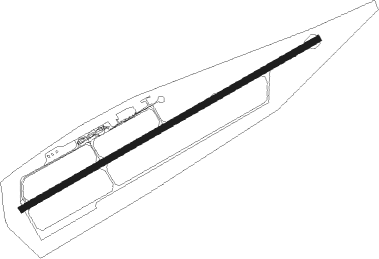
Khatanga
Airport details
| Country | Russian Federation |
| State | Krasnoyarsk Krai |
| Region | UO |
| Airspace | Krasnoyarsk Ctr |
| Municipality | сельское поселение Хатанга |
| Elevation | 98ft (30m) |
| Timezone | GMT +7 |
| Coordinates | 71.97833, 102.49333 |
| Magnetic var | |
| Type | land |
| Available since | X-Plane v10.40 |
| ICAO code | UOHH |
| IATA code | HTG |
| FAA code | n/a |
Communication
| Khatanga Khatanga METEO | 126.600 |
| Khatanga Khatanga Transit | 131.700 |
| Khatanga Khatanga VyshKka | 118.100 |
| Khatanga Khatanga Tower | 129.000 |
| Khatanga Khatanga Departures | 128.800 |
Approach frequencies
| ILS-cat-I | RW06 | 110.3 | 18.00mi |
| 2.8° GS | RW06 | 110.3 | 18.00mi |
Nearby beacons
| code | identifier | dist | bearing | frequency |
|---|---|---|---|---|
| HTG | KHATANGA VOR/DME | 0.5 | 185° | 113.10 |
| O | KHATANGA NDB | 1.1 | 262° | 681 |
| Z | KHATANGA NDB | 1.2 | 82° | 681 |
| ZT | KHATANGA NDB | 2.8 | 82° | 332 |
| OA | KHATANGA NDB | 3.7 | 262° | 332 |
Departure and arrival routes
| Transition altitude | 2395ft |
| Transition level | 4000ft |
| SID end points | distance | outbound heading | |
|---|---|---|---|
| RW06 | |||
| ORTEM1, ORTE1C | 27mi | 89° | |
| TIKMI1, TIKM1C | 27mi | 105° | |
| PESO1C, PESOR1 | 27mi | 202° | |
| DILO1C, DILOS1 | 27mi | 232° | |
| MINPI1, MINP1C | 27mi | 264° | |
| RIBNA1, RIBN1C | 27mi | 273° | |
| RELTA1, RELT1C | 27mi | 278° | |
| SUBE1C, SUBEM1 | 27mi | 327° | |
| RW24 | |||
| ORTEM3, ORTE1D | 27mi | 89° | |
| TIKM1D, TIKMI3 | 27mi | 105° | |
| PESO1D, PESOR3 | 27mi | 202° | |
| DILOS3, DILO1D | 27mi | 232° | |
| MINPI3, MINP1D | 27mi | 264° | |
| RIBN1D, RIBNA3 | 27mi | 273° | |
| RELT1D, RELTA3 | 27mi | 278° | |
| SUBE1D, SUBEM3 | 27mi | 327° | |
| STAR starting points | distance | inbound heading | |
|---|---|---|---|
| RW06 | |||
| PESO1A, PESOR2 | 26.8 | 22° | |
Instrument approach procedures
| runway | airway (heading) | route (dist, bearing) |
|---|---|---|
| RW06 | HH003 (69°) | HH003 HH002 (6mi, 303°) 1740ft |
| RW06 | HH004 (90°) | HH004 HH002 (6mi, 123°) 1740ft |
| RW06 | HH005 (82°) | HH005 HH002 (6mi, 82°) 1740ft |
| RNAV | HH002 1740ft HH001 (6mi, 82°) 1740ft UOHH (6mi, 82°) 145ft (5636mi, 235°) 760ft HH016 (5631mi, 55°) HH004 (12mi, 262°) 1740ft | |
| RW24 | HH008 (249°) | HH008 HH007 (6mi, 123°) 1690ft |
| RW24 | HH009 (270°) | HH009 HH007 (6mi, 303°) 1690ft |
| RW24 | HH010 (262°) | HH010 HH007 (6mi, 262°) 1690ft |
| RNAV | HH007 1690ft HH006 (6mi, 262°) 1690ft UOHH (6mi, 262°) 96ft (5636mi, 235°) 710ft HH017 (5633mi, 55°) HH008 (12mi, 82°) 1690ft |
Holding patterns
| STAR name | hold at | type | turn | heading* | altitude | leg | speed limit |
|---|---|---|---|---|---|---|---|
| RELT1A | HH004 | VHF | right | 330 (150)° | 1580ft - 8000ft | 1.0min timed | 280 |
| RELT1B | HH008 | VHF | left | 330 (150)° | 1530ft - 8000ft | 1.0min timed | 280 |
| RIBN1A | HH004 | VHF | right | 330 (150)° | 1580ft - 8000ft | 1.0min timed | 280 |
| RIBN1B | HH008 | VHF | left | 330 (150)° | 1530ft - 8000ft | 1.0min timed | 280 |
| SUBE1A | HH004 | VHF | right | 330 (150)° | 1580ft - 8000ft | 1.0min timed | 280 |
| SUBE1B | HH008 | VHF | left | 330 (150)° | 1530ft - 8000ft | 1.0min timed | 280 |
| *) magnetic outbound (inbound) holding course | |||||||
Disclaimer
The information on this website is not for real aviation. Use this data with the X-Plane flight simulator only! Data taken with kind consent from X-Plane 12 source code and data files. Content is subject to change without notice.
