Tyumen - Roschino Intl
Airport details
| Country | Russian Federation |
| State | Tyumen Oblast |
| Region | US |
| Airspace | Tyumen Ctr |
| Municipality | Tyumen |
| Elevation | 375ft (114m) |
| Timezone | GMT +5 |
| Coordinates | 57.18619, 65.33479 |
| Magnetic var | |
| Type | land |
| Available since | X-Plane v10.40 |
| ICAO code | USTR |
| IATA code | TJM |
| FAA code | n/a |
Communication
| Roschino Intl USTR ATIS | 121.700 |
| Roschino Intl TYUMEN TAXIING Ground Control | 119.000 |
| Roschino Intl TYUMEN START Tower | 118.200 |
| Roschino Intl TYUMEN Approach | 124.000 |
| Roschino Intl TYUMEN Approach | 126.100 |
| Roschino Intl TYUMEN KRUG Approach | 120.400 |
Approach frequencies
| ILS-cat-I | RW30 | 111.1 | 18.00mi |
| ILS-cat-I | RW03 | 108.3 | 18.00mi |
| ILS-cat-I | RW21 | 110.7 | 18.00mi |
| 3° GS | RW30 | 111.1 | 18.00mi |
| 2.7° GS | RW03 | 108.3 | 18.00mi |
| 2.7° GS | RW21 | 110.7 | 18.00mi |
Nearby Points of Interest:
Chimgi-Tura
-Public bath
-St. Joseph's Church, Tyumen
-Aleksandrovskoe real school
-Synagogue in Tyumen
-Cathedral of the Theotokos of the Sign
-Lenin Street 47, Tyumen
-25 Oktyabrya Street 13b, Tyumen
-Ushakov House, Tyumen
-All Saints Church
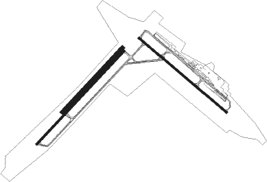
Runway info
Runway 03 / 21  | ||
| length | 2986m (9797ft) | |
| bearing | 64° / 244° | |
| width | 45m (148ft) | |
| surface | asphalt | |
| blast zone | 55m (180ft) / 55m (180ft) | |
| Runway 12 / 30 | ||
| length | 2688m (8819ft) | |
| bearing | 118° / 298° | |
| width | 50m (164ft) | |
| surface | asphalt | |
| blast zone | 55m (180ft) / 49m (161ft) | |
| Runway 03L / 21R | ||
| length | 2044m (6706ft) | |
| bearing | 64° / 244° | |
| width | 100m (328ft) | |
| surface | grass | |
Nearby beacons
| code | identifier | dist | bearing | frequency |
|---|---|---|---|---|
| URT | TYUMEN VOR/DME | 0.2 | 242° | 111.60 |
| T | ROSHCHINO (TYUMEN) NDB | 0.4 | 339° | 650 |
| X | TYUMEN NDB | 1 | 294° | 599 |
| TM | ROSHCHINO (TYUMEN) NDB | 1.9 | 53° | 315 |
| XZ | TYUMEN NDB | 2.2 | 296° | 290 |
| R | ROSHCHINO (TYUMEN) NDB | 2.5 | 251° | 650 |
| RN | ROSHCHINO (TYUMEN) NDB | 4 | 248° | 315 |
Departure and arrival routes
| Transition altitude | 2674ft |
| Transition level | 4000ft |
| SID end points | distance | outbound heading | |
|---|---|---|---|
| RW03 | |||
| LAKE1G, LAKE1Q, LAKE2F | 26mi | 18° | |
| SOLM2F, SOLM1Q, SOLM1G | 26mi | 83° | |
| NAPO1G, NAPO1Q, NAPO2F | 26mi | 95° | |
| DOME1G, DOME2F, DOME1Q | 27mi | 104° | |
| KEGI1G, KEGI2F, KEGI1Q | 25mi | 179° | |
| BUKO2F, BUKO1Q, BUKO1G | 28mi | 249° | |
| BEPA1Q, BEPA1G, BEPA2F | 28mi | 267° | |
| GORE1Q, GORE1G, GORE2F | 27mi | 298° | |
| RW12 | |||
| LAKE2H, LAKE1J, LAKE1S | 26mi | 18° | |
| SOLM1J, SOLM2H, SOLM1S | 26mi | 83° | |
| NAPO1J, NAPO2H, NAPO1S | 26mi | 95° | |
| DOME1J, DOME2H, DOME1S | 27mi | 104° | |
| KEGI1J, KEGI1S, KEGI2H | 25mi | 179° | |
| BUKO1J, BUKO2H, BUKO1S | 28mi | 249° | |
| BEPA1J, BEPA1S, BEPA2H | 28mi | 267° | |
| GORE2H, GORE1J, GORE1S | 27mi | 298° | |
| RW21 | |||
| LAKE1H, LAKE1R, LAKE2G | 26mi | 18° | |
| SOLM2G, SOLM1R, SOLM1H | 26mi | 83° | |
| NAPO1H, NAPO1R, NAPO2G | 26mi | 95° | |
| DOME1H, DOME1R, DOME2G | 27mi | 104° | |
| KEGI2G, KEGI1R, KEGI1H | 25mi | 179° | |
| BUKO2G, BUKO1R, BUKO1H | 28mi | 249° | |
| BEPA1H, BEPA1R, BEPA2G | 28mi | 267° | |
| GORE1H, GORE1R, GORE2G | 27mi | 298° | |
| RW30 | |||
| LAKE1K, LAKE2K, LAKE1T | 26mi | 18° | |
| SOLM1K, SOLM1T, SOLM2K | 26mi | 83° | |
| NAPO2K, NAPO1K, NAPO1T | 26mi | 95° | |
| DOME2K, DOME1K, DOME1T | 27mi | 104° | |
| KEGI1K, KEGI1T, KEGI2K | 25mi | 179° | |
| BUKO1K, BUKO2K, BUKO1T | 28mi | 249° | |
| BEPA1K, BEPA1T, BEPA2K | 28mi | 267° | |
| GORE1K, GORE2K, GORE1T | 27mi | 298° | |
| STAR starting points | distance | inbound heading | |
|---|---|---|---|
| RW03 | |||
| BUKO1A, BUKO1D, BUKO1L, BUKO2A | 28.4 | 69° | |
| GINP1D, GINP2A, GINP1L, GINP1A | 27.2 | 97° | |
| GORE1A, GORE1L, GORE2A, GORE1D | 26.8 | 118° | |
| DELE2A, DELE1L, DELE1D, DELE1A | 26.3 | 146° | |
| NERU1A, NERU1D, NERU1L, NERU2A | 25.7 | 241° | |
| NAPO1A, NAPO1D, NAPO1L, NAPO2A | 26.4 | 275° | |
| DOME1A, DOME1D, DOME1L, DOME2A | 26.7 | 284° | |
| KEGI1L, KEGI2A, KEGI1D, KEGI1A | 24.6 | 359° | |
| RW12 | |||
| BUKO2C, BUKO1N, BUKO1F, BUKO1C | 28.4 | 69° | |
| GINP1N, GINP1F, GINP1C | 27.2 | 97° | |
| GORE1N, GORE2C, GORE1F, GORE1C | 26.8 | 118° | |
| DELE2C, DELE1C, DELE1F, DELE1N | 26.3 | 146° | |
| NERU1C, NERU1F, NERU1N, NERU2C | 25.7 | 241° | |
| NAPO1C, NAPO1F, NAPO1N, NAPO2C | 26.4 | 275° | |
| DOME1C, DOME1F, DOME1N, DOME2C | 26.7 | 284° | |
| KEGI2C, KEGI1N, KEGI1F, KEGI1C | 24.6 | 359° | |
| RW21 | |||
| BUKO2B, BUKO1M, BUKO1E, BUKO1B | 28.4 | 69° | |
| GINP1E, GINP1M, GINP2B, GINP1B | 27.2 | 97° | |
| GORE1B, GORE1E, GORE1M, GORE2B | 26.8 | 118° | |
| DELE1B, DELE1E, DELE1M, DELE2B | 26.3 | 146° | |
| NERU1M, NERU1U, NERU2B, NERU1E, NERU1B | 25.7 | 241° | |
| NAPO1B, NAPO1M, NAPO2B, NAPO1E | 26.4 | 275° | |
| DOME2B, DOME1B, DOME1E, DOME1M | 26.7 | 284° | |
| KEGI2B, KEGI1M, KEGI1E, KEGI1B | 24.6 | 359° | |
| RW30 | |||
| BUKO2D, BUKO1P, BUKO1F | 28.4 | 69° | |
| GINP1F, GINP2D, GINP1P | 27.2 | 97° | |
| GORE1P, GORE1F, GORE2D | 26.8 | 118° | |
| DELE2D, DELE1P, DELE1F | 26.3 | 146° | |
| NERU1P, NERU2D, NERU1F | 25.7 | 241° | |
| NAPO1F, NAPO1P, NAPO2D | 26.4 | 275° | |
| DOME1F, DOME1P, DOME2D | 26.7 | 284° | |
| KEGI1F, KEGI2D, KEGI1P | 24.6 | 359° | |
Instrument approach procedures
| runway | airway (heading) | route (dist, bearing) |
|---|---|---|
| RW03 | TR002 (65°) | TR002 3000ft TR004 (6mi, 63°) 2200ft |
| RW03 | TR003 (34°) | TR003 3000ft TR004 (6mi, 301°) 2200ft |
| RW03 | TR004 (65°) | TR001 3000ft TR004 (6mi, 121°) 2200ft |
| RNAV | TR004 2200ft TR005 (5mi, 64°) 1500ft USTR (6mi, 67°) 422ft (4620mi, 229°) 1500ft TR001 (4608mi, 49°) 3000ft | |
| RW12 | TR011 (96°) | TR011 3000ft TR014 (6mi, 61°) 2200ft |
| RW12 | TR012 (118°) | TR012 3000ft TR014 (6mi, 118°) 2200ft |
| RW12 | TR013 (157°) | TR013 3000ft TR014 (6mi, 241°) 2200ft |
| RNAV | TR014 2200ft TR015 (5mi, 118°) 1500ft USTR (4mi, 117°) 365ft (4620mi, 229°) 1500ft TR011 (4611mi, 49°) 3000ft | |
| RW21 | TR006 (201°) | TR006 3000ft TR009 (6mi, 121°) 2200ft |
| RW21 | TR007 (243°) | TR007 3000ft TR009 (6mi, 244°) 2200ft |
| RW21 | TR008 (265°) | TR008 3000ft TR009 (6mi, 301°) 2200ft |
| RNAV | TR009 2200ft TR010 (5mi, 244°) 1600ft USTR (4mi, 238°) 393ft (4620mi, 229°) 1600ft TR006 (4626mi, 49°) 3000ft | |
| RW30 | TR016 (286°) | TR016 4300ft TR018 (6mi, 270°) 2800ft |
| RW30 | TR017 (337°) | TR017 3000ft TR018 (6mi, 61°) 2800ft |
| RNAV | TR018 2800ft TR019 (5mi, 298°) 1600ft USTR (5mi, 299°) 395ft (4620mi, 229°) 1600ft TR017 (4619mi, 49°) 3000ft |
Holding patterns
| STAR name | hold at | type | turn | heading* | altitude | leg | speed limit |
|---|---|---|---|---|---|---|---|
| BUKO1A | RN | FIX | left | 213 (33)° | > 1600ft | 1.0min timed | 215 |
| BUKO1B | TM | FIX | right | 33 (213)° | > 1600ft | 1.0min timed | 215 |
| BUKO1C | XZ | FIX | right | 300 (120)° | > 1600ft | 1.0min timed | 215 |
| BUKO1D | R | NDB | right | 31 (211)° | 4350ft - 6000ft | 1.0min timed | ICAO rules |
| BUKO1E | T | NDB | right | 195 (15)° | > 1800ft | 1.0min timed | 210 |
| BUKO1F | X | FIX | right | 300 (120)° | > 1600ft | 1.0min timed | 215 |
| BUKO1M | TR006 | VHF | left | 303 (123)° | 1500ft - 60000ft | 1.0min timed | ICAO rules |
| BUKO1N | TR011 | VHF | left | 210 (30)° | 1600ft - 60000ft | 1.0min timed | ICAO rules |
| BUKO1P | TR017 | VHF | left | 230 (50)° | 2100ft - 60000ft | 1.0min timed | 250 |
| BUKO2A | URT | NDB | right | 195 (15)° | > 1800ft | 1.0min timed | 210 |
| BUKO2B | URT | NDB | right | 195 (15)° | > 1800ft | 1.0min timed | 210 |
| DELE1A | RN | FIX | left | 213 (33)° | > 1600ft | 1.0min timed | 215 |
| DELE1B | TM | FIX | right | 33 (213)° | > 1600ft | 1.0min timed | 215 |
| DELE1C | XZ | FIX | right | 300 (120)° | > 1600ft | 1.0min timed | 215 |
| DELE1D | R | NDB | right | 31 (211)° | 4350ft - 6000ft | 1.0min timed | ICAO rules |
| DELE1E | T | NDB | right | 195 (15)° | > 1800ft | 1.0min timed | 210 |
| DELE1F | X | FIX | right | 300 (120)° | > 1600ft | 1.0min timed | 215 |
| DELE1L | TR001 | VHF | right | 303 (123)° | 1600ft - 60000ft | 1.0min timed | ICAO rules |
| DELE1M | TR006 | VHF | left | 303 (123)° | 1500ft - 60000ft | 1.0min timed | ICAO rules |
| DELE2A | URT | NDB | right | 195 (15)° | > 1800ft | 1.0min timed | 210 |
| DELE2D | URT | NDB | right | 195 (15)° | > 1800ft | 1.0min timed | 210 |
| DOME1A | RN | FIX | left | 213 (33)° | > 1600ft | 1.0min timed | 215 |
| DOME1B | TM | FIX | right | 33 (213)° | > 1600ft | 1.0min timed | 215 |
| DOME1C | XZ | FIX | right | 300 (120)° | > 1600ft | 1.0min timed | 215 |
| DOME1D | R | NDB | right | 31 (211)° | 4350ft - 6000ft | 1.0min timed | ICAO rules |
| DOME1E | T | NDB | right | 195 (15)° | > 1800ft | 1.0min timed | 210 |
| DOME1F | X | FIX | right | 300 (120)° | > 1600ft | 1.0min timed | 215 |
| DOME2A | URT | NDB | right | 195 (15)° | > 1800ft | 1.0min timed | 210 |
| DOME2C | URT | NDB | right | 195 (15)° | > 1800ft | 1.0min timed | 210 |
| GINP1A | RN | FIX | left | 213 (33)° | > 1600ft | 1.0min timed | 215 |
| GINP1B | TM | FIX | right | 33 (213)° | > 1600ft | 1.0min timed | 215 |
| GINP1C | XZ | FIX | right | 300 (120)° | > 1600ft | 1.0min timed | 215 |
| GINP1D | R | NDB | right | 31 (211)° | 4350ft - 6000ft | 1.0min timed | ICAO rules |
| GINP1E | T | NDB | right | 195 (15)° | > 1800ft | 1.0min timed | 210 |
| GINP1F | X | FIX | right | 300 (120)° | > 1600ft | 1.0min timed | 215 |
| GINP1L | TR001 | VHF | right | 303 (123)° | 1600ft - 60000ft | 1.0min timed | ICAO rules |
| GINP1M | TR006 | VHF | left | 303 (123)° | 1500ft - 60000ft | 1.0min timed | ICAO rules |
| GINP1N | TR011 | VHF | left | 210 (30)° | 1600ft - 60000ft | 1.0min timed | ICAO rules |
| GINP1P | TR017 | VHF | left | 230 (50)° | 2100ft - 60000ft | 1.0min timed | 250 |
| GINP2B | URT | NDB | right | 195 (15)° | > 1800ft | 1.0min timed | 210 |
| GINP2D | URT | NDB | right | 195 (15)° | > 1800ft | 1.0min timed | 210 |
| GORE1A | RN | FIX | left | 213 (33)° | > 1600ft | 1.0min timed | 215 |
| GORE1B | TM | FIX | right | 33 (213)° | > 1600ft | 1.0min timed | 215 |
| GORE1C | XZ | FIX | right | 300 (120)° | > 1600ft | 1.0min timed | 215 |
| GORE1D | R | NDB | right | 31 (211)° | 4350ft - 6000ft | 1.0min timed | ICAO rules |
| GORE1E | T | NDB | right | 195 (15)° | > 1800ft | 1.0min timed | 210 |
| GORE1F | X | FIX | right | 300 (120)° | > 1600ft | 1.0min timed | 215 |
| GORE1L | TR001 | VHF | right | 303 (123)° | 1600ft - 60000ft | 1.0min timed | ICAO rules |
| GORE1M | TR006 | VHF | left | 303 (123)° | 1500ft - 60000ft | 1.0min timed | ICAO rules |
| GORE1P | TR017 | VHF | left | 230 (50)° | 2100ft - 60000ft | 1.0min timed | 250 |
| GORE2C | URT | NDB | right | 195 (15)° | > 1800ft | 1.0min timed | 210 |
| GORE2D | URT | NDB | right | 195 (15)° | > 1800ft | 1.0min timed | 210 |
| KEGI1A | RN | FIX | left | 213 (33)° | > 1600ft | 1.0min timed | 215 |
| KEGI1B | TM | FIX | right | 33 (213)° | > 1600ft | 1.0min timed | 215 |
| KEGI1C | XZ | FIX | right | 300 (120)° | > 1600ft | 1.0min timed | 215 |
| KEGI1D | R | NDB | right | 31 (211)° | 4350ft - 6000ft | 1.0min timed | ICAO rules |
| KEGI1E | T | NDB | right | 195 (15)° | > 1800ft | 1.0min timed | 210 |
| KEGI1F | X | FIX | right | 300 (120)° | > 1600ft | 1.0min timed | 215 |
| KEGI1N | TR011 | VHF | left | 210 (30)° | 1600ft - 60000ft | 1.0min timed | ICAO rules |
| KEGI1P | TR017 | VHF | left | 230 (50)° | 2100ft - 60000ft | 1.0min timed | 250 |
| KEGI2B | URT | NDB | right | 195 (15)° | > 1800ft | 1.0min timed | 210 |
| KEGI2C | URT | NDB | right | 195 (15)° | > 1800ft | 1.0min timed | 210 |
| NAPO1A | RN | FIX | left | 213 (33)° | > 1600ft | 1.0min timed | 215 |
| NAPO1B | TM | FIX | right | 33 (213)° | > 1600ft | 1.0min timed | 215 |
| NAPO1C | XZ | FIX | right | 300 (120)° | > 1600ft | 1.0min timed | 215 |
| NAPO1D | R | NDB | right | 31 (211)° | 4350ft - 6000ft | 1.0min timed | ICAO rules |
| NAPO1E | T | NDB | right | 195 (15)° | > 1800ft | 1.0min timed | 210 |
| NAPO1F | X | FIX | right | 300 (120)° | > 1600ft | 1.0min timed | 215 |
| NAPO2A | URT | NDB | right | 195 (15)° | > 1800ft | 1.0min timed | 210 |
| NAPO2C | URT | NDB | right | 195 (15)° | > 1800ft | 1.0min timed | 210 |
| NERU1A | RN | FIX | left | 213 (33)° | > 1600ft | 1.0min timed | 215 |
| NERU1B | TM | FIX | right | 33 (213)° | > 1600ft | 1.0min timed | 215 |
| NERU1C | XZ | FIX | right | 300 (120)° | > 1600ft | 1.0min timed | 215 |
| NERU1D | R | NDB | right | 31 (211)° | 4350ft - 6000ft | 1.0min timed | ICAO rules |
| NERU1E | T | NDB | right | 195 (15)° | > 1800ft | 1.0min timed | 210 |
| NERU1F | X | FIX | right | 300 (120)° | > 1600ft | 1.0min timed | 215 |
| NERU2A | URT | NDB | right | 195 (15)° | > 1800ft | 1.0min timed | 210 |
| NERU2B | URT | NDB | right | 195 (15)° | > 1800ft | 1.0min timed | 210 |
| *) magnetic outbound (inbound) holding course | |||||||
Disclaimer
The information on this website is not for real aviation. Use this data with the X-Plane flight simulator only! Data taken with kind consent from X-Plane 12 source code and data files. Content is subject to change without notice.