Bhubaneswar
Airport details
| Country | India |
| State | Odisha |
| Region | VE |
| Airspace | Kolkata Ctr |
| Municipality | Bhubaneswar Municipal Corporation |
| Elevation | 138ft (42m) |
| Timezone | GMT +5.5 |
| Coordinates | 20.25836, 85.81168 |
| Magnetic var | |
| Type | land |
| Available since | X-Plane v10.40 |
| ICAO code | VEBS |
| IATA code | BBI |
| FAA code | n/a |
Communication
| Bhubaneswar ATIS | 126.800 |
| Bhubaneswar Tower | 125.150 |
| Bhubaneswar Approach | 123.500 |
Approach frequencies
| ILS-cat-I | RW14 | 109.1 | 18.00mi |
| 3° GS | RW14 | 109.1 | 18.00mi |
Nearby Points of Interest:
Bhubaneswar
-Rameshwar Deula
-Bhaskareswar Temple
-Sidheswar Temple
-Parsurameswar Temple
-Megheswar Temple
-Chausathi Jogini Temple
-Buddhanath Temple
-Varahi Deula
-Kapilash Temple
-Atharanala
-Pushpagiri
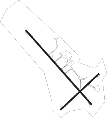
Runway info
Runway 14 / 32  | ||
| length | 2753m (9032ft) | |
| bearing | 141° / 321° | |
| width | 46m (150ft) | |
| surface | asphalt | |
| blast zone | 255m (837ft) / 62m (203ft) | |
| Runway 05 / 23 | ||
| length | 1455m (4774ft) | |
| bearing | 53° / 233° | |
| width | 46m (150ft) | |
| surface | asphalt | |
| displ threshold | 61m (200ft) / 61m (200ft) | |
Nearby beacons
| code | identifier | dist | bearing | frequency |
|---|---|---|---|---|
| BBS | BHUBANESWAR VOR/DME | 0.8 | 175° | 113.50 |
Instrument approach procedures
| runway | airway (heading) | route (dist, bearing) |
|---|---|---|
| RW14-Y | BS441 (141°) | BS441 3300ft BS112 (5mi, 142°) 2400ft |
| RW14-Y | BS443 (112°) | BS443 3300ft BS112 (7mi, 55°) 2400ft |
| RNAV | BS112 2400ft BS113 (5mi, 142°) 2200ft VEBS (7mi, 140°) 155ft BS101 (7mi, 144°) BS103 (7mi, 235°) BS443 (19mi, 322°) 3300ft BS443 (turn) 3300ft | |
| RW32-Y | BS661 (296°) | BS661 3300ft BS020 (7mi, 235°) 2400ft |
| RW32-Y | BS662 (323°) | BS662 3300ft BS020 (7mi, 322°) 2400ft |
| RW32-Y | BS663 (351°) | BS663 3300ft BS020 (7mi, 55°) 2400ft |
| RNAV | BS020 2400ft BS019 (6mi, 322°) 2200ft VEBS (8mi, 324°) 175ft BS601 (6mi, 320°) BS603 (7mi, 235°) BS663 (20mi, 142°) BS020 (7mi, 55°) 2400ft BS020 (turn) 2400ft |
Disclaimer
The information on this website is not for real aviation. Use this data with the X-Plane flight simulator only! Data taken with kind consent from X-Plane 12 source code and data files. Content is subject to change without notice.