Agra Ab
Airport details
| Country | India |
| State | Uttar Pradesh |
| Region | VI |
| Airspace | Delhi Ctr |
| Municipality | Agra |
| Elevation | 550ft (168m) |
| Timezone | GMT +5.5 |
| Coordinates | 27.16667, 77.96667 |
| Magnetic var | |
| Type | land |
| Available since | X-Plane v10.30 |
| ICAO code | VIAG |
| IATA code | AGR |
| FAA code | n/a |
Communication
| Agra AB Tower | 119.700 |
| Agra AB Approach | 122.300 |
Nearby Points of Interest:
Akbar's Church
-Panch Mahal
-Fatehpur Sikri
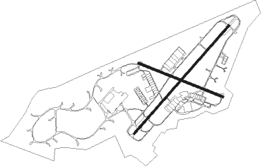
Runway info
Runway 05 / 23  | ||
| length | 2876m (9436ft) | |
| bearing | 49° / 229° | |
| width | 45m (148ft) | |
| surface | asphalt | |
| displ threshold | 130m (427ft) / 0m (0ft) | |
| Runway 12 / 30 | ||
| length | 1812m (5945ft) | |
| bearing | 114° / 294° | |
| width | 45m (148ft) | |
| surface | asphalt | |
Nearby beacons
| code | identifier | dist | bearing | frequency |
|---|---|---|---|---|
| AGG | AGRA VOR/DME | 0.7 | 227° | 112 |
| AG | AGRA NDB | 0.9 | 185° | 249 |
| ALI | ALIGARH VOR/DME | 41.3 | 18° | 117.90 |
| GWA | GWALIOR VOR/DME | 54 | 163° | 112.80 |
| SKA | SAKRAS VOR/DME | 65.4 | 305° | 117.20 |
Disclaimer
The information on this website is not for real aviation. Use this data with the X-Plane flight simulator only! Data taken with kind consent from X-Plane 12 source code and data files. Content is subject to change without notice.