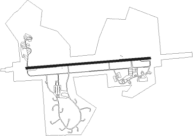
Sharanpur - Sarsawa
Airport details
| Country | India |
| State | Uttar Pradesh |
| Region | VI |
| Airspace | Delhi Ctr |
| Municipality | Nakur |
| Elevation | 891ft (272m) |
| Timezone | GMT +5.5 |
| Coordinates | 29.99227, 77.43414 |
| Magnetic var | |
| Type | land |
| Available since | X-Plane v10.40 |
| ICAO code | VISP |
| IATA code | n/a |
| FAA code | n/a |
Communication
Nearby Points of Interest:
Sugh Ancient Mound
-Nabha House
Nearby beacons
| code | identifier | dist | bearing | frequency |
|---|---|---|---|---|
| SP | SARSAWA NDB | 0.4 | 344° | 298 |
| DDN | DEHRADUN VOR/DME | 39.8 | 75° | 112.60 |
| CG | CHANDIGARH NDB | 52.4 | 318° | 228 |
| CHG | CHANDIGARH VOR/DME | 53.9 | 316° | 116.50 |
Disclaimer
The information on this website is not for real aviation. Use this data with the X-Plane flight simulator only! Data taken with kind consent from X-Plane 12 source code and data files. Content is subject to change without notice.