Madurai
Airport details
| Country | India |
| State | Tamil Nadu |
| Region | VO |
| Airspace | Chennai Ctr |
| Municipality | Madurai |
| Elevation | 458ft (140m) |
| Timezone | GMT +5.5 |
| Coordinates | 9.83528, 78.08833 |
| Magnetic var | |
| Type | land |
| Available since | X-Plane v10.40 |
| ICAO code | VOMD |
| IATA code | IXM |
| FAA code | n/a |
Communication
| Madurai Tower | 122.800 |
| Madurai Approach | 122.800 |
Approach frequencies
| ILS-cat-I | RW27 | 110.5 | 18.00mi |
| 3° GS | RW27 | 110.5 | 18.00mi |
Nearby Points of Interest:
Thirumalai Nayakkar Mahal
-Shanmughanathar Temple, Kunnakudi
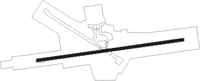
Runway info
| Runway 09 / 27 | ||
| length | 2290m (7513ft) | |
| bearing | 86° / 266° | |
| width | 45m (148ft) | |
| surface | asphalt | |
| displ threshold | 0m (0ft) / 62m (203ft) | |
| blast zone | 0m (0ft) / 58m (190ft) | |
Nearby beacons
| code | identifier | dist | bearing | frequency |
|---|---|---|---|---|
| MDI | MADURAI VOR/DME | 0.2 | 166° | 116.10 |
| MD | MADURAI NDB | 0.8 | 60° | 400 |
| TTR | TIRUCHIRAPPALLI VOR/DME | 67.5 | 34° | 113.10 |
Disclaimer
The information on this website is not for real aviation. Use this data with the X-Plane flight simulator only! Data taken with kind consent from X-Plane 12 source code and data files. Content is subject to change without notice.