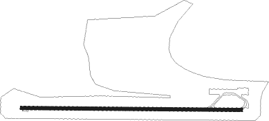
Kudahuvadhoo - Dhaalu
Airport details
| Country | Maldives |
| State | Nilandhe Atholhu Dhekunuburi |
| Region | VR |
| Airspace | Male Ctr |
| Elevation | 4ft (1m) |
| Timezone | GMT +5 |
| Coordinates | 2.66686, 72.87794 |
| Magnetic var | |
| Type | land |
| Available since | X-Plane v11.51r1 |
| ICAO code | VRMU |
| IATA code | DDD |
| FAA code | n/a |
Communication
| Dhaalu AFIS Maldives | 128.900 |
| Dhaalu Dhaalu Tower | 118.550 |
Runway info
| Runway 10 / 28 | ||
| length | 1802m (5912ft) | |
| bearing | 95° / 275° | |
| width | 30m (98ft) | |
| surface | asphalt | |
| blast zone | 0m (0ft) / 61m (200ft) | |
Nearby beacons
| code | identifier | dist | bearing | frequency |
|---|---|---|---|---|
| KD | KADHDHOO NDB | 62.2 | 142° | 260 |
Instrument approach procedures
| runway | airway (heading) | route (dist, bearing) |
|---|---|---|
| RW10 | BEKIM (126°) | BEKIM MU422 (5mi, 185°) 1600ft |
| RW10 | TOMEM (64°) | TOMEM MU422 (5mi, 5°) 1600ft |
| RNAV | MU422 1600ft MU421 (3mi, 95°) 1600ft VRMU (5mi, 95°) 56ft (4379mi, 268°) 500ft TOMEM (4369mi, 88°) TOMEM (turn) 3000ft | |
| RW28 | IGREB (247°) | IGREB MU424 (5mi, 185°) 1600ft |
| RW28 | LASOG (303°) | LASOG MU424 (5mi, 5°) 1600ft |
| RNAV | MU424 1600ft MU423 (3mi, 275°) 1600ft VRMU (5mi, 275°) 56ft (4379mi, 268°) 500ft LASOG (4387mi, 88°) LASOG (turn) 3000ft |
Disclaimer
The information on this website is not for real aviation. Use this data with the X-Plane flight simulator only! Data taken with kind consent from X-Plane 12 source code and data files. Content is subject to change without notice.
