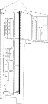
Rayong - Rayon U-taphao Intl
Airport details
| Country | Thailand |
| State | Rayong Province |
| Region | VT |
| Airspace | Bangkok Ctr |
| Municipality | Phala |
| Elevation | 59ft (18m) |
| Timezone | GMT +7 |
| Coordinates | 12.67961, 101.00491 |
| Magnetic var | |
| Type | land |
| Available since | X-Plane v10.40 |
| ICAO code | VTBU |
| IATA code | UTP |
| FAA code | n/a |
Communication
| Rayon U-Taphao Intl Ground Control | 121.900 |
| Rayon U-Taphao Intl Tower | 118.300 |
| Rayon U-Taphao Intl Tower | 118.100 |
| Rayon U-Taphao Intl Approach | 134.500 |
| Rayon U-Taphao Intl Approach | 119.700 |
Approach frequencies
| ILS-cat-I | RW18 | 111.1 | 18.00mi |
| 3° GS | RW18 | 111.1 | 18.00mi |
Nearby beacons
| code | identifier | dist | bearing | frequency |
|---|---|---|---|---|
| BUT | U-TAPAO VOR/DME | 0.8 | 199° | 110.80 |
| UP | U-TAPHAO NDB | 1.2 | 209° | 414 |
| UT | U-TAPHAO INTL (RAYONG) NDB | 1.3 | 347° | 234 |
| RYN | RAYONG VOR/DME | 39.9 | 82° | 112.50 |
| SVB | SUVARNABHUMI (BANGKOK) VOR/DME | 60.9 | 344° | 111.40 |
Departure and arrival routes
| Transition altitude | 11000ft |
| Transition level | 13000ft |
| SID end points | distance | outbound heading | |
|---|---|---|---|
| RW18 | |||
| BKK1A | 77mi | 341° | |
| RW36 | |||
| BKK1B | 77mi | 341° | |
Instrument approach procedures
| runway | airway (heading) | route (dist, bearing) |
|---|---|---|
| RW18 | PINYA (204°) | PINYA 4000ft NAVIG (5mi, 250°) 2500ft |
| RW18 | SILAA (165°) | SILAA 4000ft NAVIG (5mi, 119°) 2500ft |
| RNAV | NAVIG 2500ft UTPNF (5mi, 185°) 1700ft UTPNM (5mi, 185°) 109ft SAMIT (5mi, 185°) SAMIT (turn) 1500ft SNOVY (7mi, 107°) IFONE (13mi, 63°) 4000ft IFONE (turn) 4000ft | |
| RW36 | HAMOO (45°) | HAMOO 3000ft ZEHOC (8mi, 90°) 2000ft |
| RW36 | MONJA (336°) | MONJA 3000ft ZEHOC (8mi, 304°) 2000ft |
| RNAV | ZEHOC 2000ft UTPSF (5mi, 5°) 1100ft UTPSM (3mi, 5°) 74ft (6050mi, 263°) 2500ft COBAR (6062mi, 83°) 4000ft COBAR (turn) 4000ft |
Disclaimer
The information on this website is not for real aviation. Use this data with the X-Plane flight simulator only! Data taken with kind consent from X-Plane 12 source code and data files. Content is subject to change without notice.
