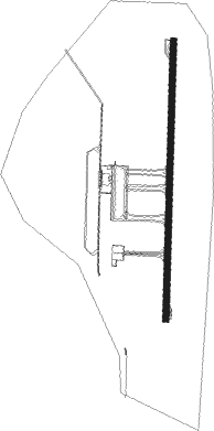
Nakhon Si Thammarat
Airport details
| Country | Thailand |
| State | Nakhon Si Thammarat Province |
| Region | VT |
| Airspace | Bangkok Ctr |
| Municipality | Pak Phun |
| Elevation | 13ft (4m) |
| Timezone | GMT +7 |
| Coordinates | 8.53962, 99.94473 |
| Magnetic var | |
| Type | land |
| Available since | X-Plane v10.40 |
| ICAO code | VTSF |
| IATA code | NST |
| FAA code | n/a |
Communication
| Nakhon Si Thammarat ATIS | 123.400 |
| Nakhon Si Thammarat Ground Control | 121.900 |
| Nakhon Si Thammarat Tower | 122.550 |
| Nakhon Si Thammarat Approach | 129.600 |
| Nakhon Si Thammarat Approach | 119.750 |
Approach frequencies
| ILS-cat-I | RW19 | 109.7 | 18.00mi |
| 3° GS | RW19 | 109.7 | 18.00mi |
Nearby beacons
| code | identifier | dist | bearing | frequency |
|---|---|---|---|---|
| NKS | NAKHON SI THAMMARAT VOR/DME | 0.1 | 46° | 117.40 |
| SRT | SURAT THANI TACAN | 59.7 | 306° | 113.20 |
| STN | SURAT THANI VOR/DME | 59.7 | 306° | 110.60 |
| KBI | KRABI VOR/DME | 63 | 246° | 111 |
| KB | KRABI NDB | 63.2 | 246° | 299 |
Departure and arrival routes
| Transition altitude | 11000ft |
| Transition level | 13000ft |
| SID end points | distance | outbound heading | |
|---|---|---|---|
| RW01 | |||
| GIFB1A | 77mi | 25° | |
| TAWI1A | 62mi | 25° | |
| WADE1A | 100mi | 165° | |
| PEDO1A | 65mi | 197° | |
| RW19 | |||
| GIFB1B | 77mi | 25° | |
| TAWI1B | 62mi | 25° | |
| WADE1B | 100mi | 165° | |
| PEDO1B | 65mi | 197° | |
Instrument approach procedures
| runway | airway (heading) | route (dist, bearing) |
|---|---|---|
| RW01 | CHARY (344°) | CHARY 4500ft NSTSI (10mi, 323°) 2300ft |
| RW01 | GIFBY (270°) | GIFBY 4000ft ALBAR (16mi, 270°) 4000ft NAMFA (13mi, 219°) 4000ft NSTSI (7mi, 276°) 2300ft |
| RW01 | MEZZI (17°) | MEZZI 4500ft NSTSI (9mi, 29°) 2300ft |
| RW01 | PUYOL (126°) | PUYOL 9000ft BUZKE (15mi, 126°) 7000ft ZARBY (13mi, 186°) 4000ft NSTSI (5mi, 96°) 2300ft |
| RW01 | TAWIT (205°) | TAWIT 5000ft FAGAS (9mi, 186°) 5000ft TENYO (7mi, 186°) 5000ft NAMFA (13mi, 186°) 4000ft NSTSI (7mi, 276°) 2300ft |
| RNAV | NSTSI 2300ft NSTSF (5mi, 6°) 1300ft MR01 (3mi, 6°) 446ft (5996mi, 265°) 2000ft ALBAR (6010mi, 85°) 4000ft ALBAR (turn) 4000ft | |
| RW19 | GIFBY (270°) | GIFBY 4000ft JELRY (14mi, 270°) 4000ft HAVAS (14mi, 325°) 4000ft NSTNI (7mi, 276°) 3000ft |
| RW19 | PEDOR (17°) | PEDOR 8000ft RAMOZ (34mi, 4°) 7000ft BENSY (8mi, 6°) 5000ft NSTNI (7mi, 96°) 3000ft |
| RW19 | PUYOL (126°) | PUYOL 9000ft BENSY (11mi, 88°) 5000ft NSTNI (7mi, 96°) 3000ft |
| RW19 | TAWIT (205°) | TAWIT 5000ft NSTNI (9mi, 231°) 3000ft |
| RW19 | WADEZ (344°) | WADEZ 8000ft ZEYAS (17mi, 0°) 7000ft HAVAS (23mi, 0°) 4000ft NSTNI (7mi, 276°) 3000ft |
| RNAV | NSTNI 3000ft NSTNF (7mi, 186°) 1600ft MA19 (4mi, 186°) 446ft (5996mi, 265°) 2000ft JELRY (6012mi, 85°) 4000ft JELRY (turn) 4000ft |
Disclaimer
The information on this website is not for real aviation. Use this data with the X-Plane flight simulator only! Data taken with kind consent from X-Plane 12 source code and data files. Content is subject to change without notice.
