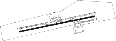
Hat Yai - Hat Yai Intl
Airport details
| Country | Thailand |
| State | Songkhla Province |
| Region | VT |
| Airspace | Bangkok Ctr |
| Municipality | Khok Muang |
| Elevation | 88ft (27m) |
| Timezone | GMT +7 |
| Coordinates | 6.93159, 100.40134 |
| Magnetic var | |
| Type | land |
| Available since | X-Plane v10.40 |
| ICAO code | VTSS |
| IATA code | HDY |
| FAA code | n/a |
Communication
| Hat Yai Intl VTSS ATIS | 128.800 |
| Hat Yai Intl HAT_YAI Ground Control | 121.900 |
| Hat Yai Intl HAT_YAI Tower | 118.100 |
| Hat Yai Intl HAT_YAI Approach | 126.700 |
Approach frequencies
| ILS-cat-I | RW26 | 109.9 | 18.00mi |
| 3° GS | RW26 | 109.9 | 18.00mi |
Nearby Points of Interest:
Wat Khuean Nang Kaeo
Nearby beacons
| code | identifier | dist | bearing | frequency |
|---|---|---|---|---|
| HTY | HAT YAI VOR/DME | 0.8 | 281° | 115.30 |
| SK | SONGKHLA NDB | 19.5 | 38° | 410 |
| SKL | SONGKHLA VOR/DME | 19.6 | 38° | 113.50 |
| VAS | ALOR SETAR VOR/DME | 44.7 | 180° | 113.60 |
| PT | PATTANI NDB | 45.3 | 101° | 201 |
| AT | ALOR STAR NDB | 46.4 | 182° | 385 |
| VPL | LANGKAWI VOR/DME | 52.2 | 229° | 114.10 |
| TRN | TRANG VOR/DME | 57.7 | 307° | 116.60 |
Instrument approach procedures
| runway | airway (heading) | route (dist, bearing) |
|---|---|---|
| RW08 | NABON (126°) | NABON 5000ft KOOHA (5mi, 214°) 5000ft PUKAO (8mi, 181°) 4200ft HURAE (5mi, 91°) 3200ft |
| RW08 | PADAM (46°) | PADAM 4200ft HURAE (5mi, 343°) 3200ft |
| RNAV | HURAE 3200ft WANPA (2mi, 53°) 2800ft FR08 (4mi, 53°) 1700ft VTSS (6mi, 84°) 115ft (6025mi, 266°) 1500ft NABON (6013mi, 86°) 5000ft NABON (turn) | |
| RW26 | BANPU (262°) | BANPU 3100ft |
| RW26 | BINLA (232°) | BINLA 4500ft BANPU (7mi, 173°) 3100ft |
| RW26 | DAWAN (292°) | DAWAN 4500ft BANPU (7mi, 353°) 3100ft |
| RNAV | BANPU 3100ft FR26 (5mi, 263°) 2000ft VTSS (6mi, 262°) 113ft (6025mi, 266°) 1000ft BANPU (6036mi, 86°) 3100ft BANPU (turn) |
Disclaimer
The information on this website is not for real aviation. Use this data with the X-Plane flight simulator only! Data taken with kind consent from X-Plane 12 source code and data files. Content is subject to change without notice.
