Mid Atlantic Soaring Center
Airport details
| Country | United States of America |
| State | Pennsylvania |
| Region | |
| Airspace | New York Ctr |
| Municipality | Adams County |
| Elevation | 573ft (175m) |
| Timezone | GMT -5 |
| Coordinates | 39.76008, -77.35445 |
| Magnetic var | |
| Type | land |
| Available since | X-Plane v10.40 |
| ICAO code | W73 |
| IATA code | n/a |
| FAA code | W73 |
Communication
Nearby Points of Interest:
Fairfield Historic District
-Bridge in Cumberland Township
-Lower Marsh Creek Presbyterian Church
-St. Euphemia's School and Sisters' House
-Emmitsburg Historic District
-St. Joseph's College and Mother Seton Shrine
-Black Horse Tavern
-Horner House and Barn
-Monterey Historic District
-Victor Cullen Center, Old Administration Building
-Victor Cullen School Power House
-John Eyler Farmstead
-Jacob M. Funk Farm
-Fourpoints Bridge
-Spangler-Benner Farm
-Gettysburg Armory
-Schmucker Hall
-Gettysburg Battlefield Historic District
-Sheads House
-Tipahato
-Adams County Courthouse
-Pennsylvania Hall
-Rock Creek-White Run Union Hospital Complex
-Jeremiah Burns Farm
-Camp Misty Mount Historic District
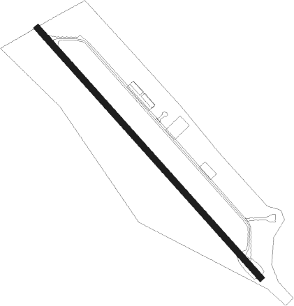
Runway info
| Runway 15 / 33 | ||
| length | 823m (2700ft) | |
| bearing | 135° / 315° | |
| width | 15m (50ft) | |
| surface | asphalt | |
| displ threshold | 0m (0ft) / 271m (889ft) | |
Nearby beacons
| code | identifier | dist | bearing | frequency |
|---|---|---|---|---|
| FDK | FREDERICK VOR | 20.9 | 183° | 109 |
| HGR | HAGERSTOWN VOR | 23.4 | 263° | 109.80 |
| EMI | WESTMINSTER VORTAC | 23.5 | 125° | 117.90 |
| THS | SAINT THOMAS VORTAC | 29.4 | 286° | 115 |
| CX | LATLE (HARRISBURG) NDB | 29.8 | 40° | 219 |
| MRB | MARTINSBURG VORTAC | 32 | 233° | 112.10 |
| HAR | HARRISBURG VORTAC | 35 | 28° | 112.50 |
| MD | ENOLA (HARRISBURG) NDB | 35.8 | 43° | 204 |
| FND | ELLICOTT (BALTIMORE) NDB | 39 | 129° | 371 |
| BAL | BALTIMORE VORTAC | 47.7 | 130° | 115.10 |
| BUH | ANNE ARUNDEL (FT MEADE) NDB | 49 | 139° | 260 |
| AML | ARMEL (WASH.,D.C.) VOR/DME | 49.8 | 188° | 113.50 |
| MTN | MARTIN (BALTIMORE) TACAN | 50.7 | 114° | 134.10 |
| GTN | GEORGETOWN (WASH., D.C.) NDB | 50.9 | 164° | 323 |
| BZJ | BELLGROVE (INDIANTOWN GAP) NDB | 54.7 | 50° | 328 |
| DCA | WASHINGTON, D.C. VOR/DME | 56 | 161° | 111 |
| RAV | RAVINE VORTAC | 58.9 | 44° | 114.60 |
| ADW | ANDREWS (CAMP SPRINGS) VORTAC | 61.5 | 153° | 113.10 |
| DCA | OXONN (WASHINGTON) NDB | 61.6 | 162° | 332 |
| LDN | LINDEN VORTAC | 67.2 | 223° | 114.30 |
Disclaimer
The information on this website is not for real aviation. Use this data with the X-Plane flight simulator only! Data taken with kind consent from X-Plane 12 source code and data files. Content is subject to change without notice.