Vancouver - Green Mountain
Airport details
| Country | United States of America |
| State | Washington |
| Region | |
| Airspace | Seattle Ctr |
| Municipality | Clark County |
| Elevation | 279ft (85m) |
| Timezone | GMT -8 |
| Coordinates | 45.66326, -122.47614 |
| Magnetic var | |
| Type | land |
| Available since | X-Plane v10.40 |
| ICAO code | WA67 |
| IATA code | n/a |
| FAA code | WA67 |
Communication
Nearby Points of Interest:
Pittock House
-John Roffler House
-Farrell Building
-John Stanger House
-Jacob Zimmerman House
-Venersborg School
-Washington School for the Blind
-Shriners Hospital for Crippled Children
-Covington House
-Multnomah County Poor Farm
-Raymond and Catherine Fisher House
-Vancouver National Historic Reserve Historic District
-John P. and Mary Kiggins House
-House of Providence
-Vancouver Telephone Building
-Elks Building
-Slocum House
-Troutdale Methodist Episcopal Church
-Louise Home Hospital and Residence Hall
-Jantzen Beach Carousel
-Virgil and Beulah Crum House
-Tannler–Armstrong House
-Oliver and Margaret Jeffrey House
-Zimmerman–Rudeen House
-Frank C. Barnes House
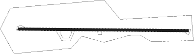
Runway info
| Runway 9 / 27 | ||
| length | 537m (1762ft) | |
| bearing | 94° / 274° | |
| width | 8m (26ft) | |
| surface | asphalt | |
Nearby beacons
| code | identifier | dist | bearing | frequency |
|---|---|---|---|---|
| BTG | BATTLE GROUND VORTAC | 7 | 306° | 116.60 |
| CBU | COLUMBIA (PORTLAND) TACAN | 7.2 | 241° | 109.20 |
| PND | BANKS (PORTLAND) NDB | 23.9 | 267° | 356 |
| UBG | NEWBERG VOR/DME | 28.1 | 238° | 117.40 |
| SL | TURNO (SALEM) NDB | 52.9 | 210° | 266 |
Disclaimer
The information on this website is not for real aviation. Use this data with the X-Plane flight simulator only! Data taken with kind consent from X-Plane 12 source code and data files. Content is subject to change without notice.