Yogyakarta-java Island - Adisutjipto Intl
Airport details
| Country | Indonesia |
| State | Special Region of Yogyakarta |
| Region | WA |
| Airspace | Ujung Pandang Ctr |
| Municipality | Maguwoharjo |
| Elevation | 377ft (115m) |
| Timezone | GMT +7 |
| Coordinates | -7.78667, 110.43195 |
| Magnetic var | |
| Type | land |
| Available since | X-Plane v10.30 |
| ICAO code | WARJ |
| IATA code | JOG |
| FAA code | n/a |
Communication
| Adisutjipto Intl ATIS | 128.500 |
| Adisutjipto Intl Ground | 118.500 |
| Adisutjipto Intl Tower | 122.400 |
| Adisutjipto Intl Tower Secondary Freq | 118.100 |
| Adisutjipto Intl Approach | 123.400 |
Nearby Points of Interest:
Prambanan
-Yogyakarta City
-Borobudur Temple Compounds
-Sangiran
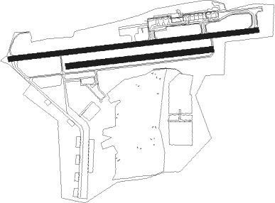
Runway info
Runway 9R / 27L  | ||
| length | 1275m (4183ft) | |
| bearing | 88° / 268° | |
| width | 50m (164ft) | |
| surface | grass | |
| Runway 9 / 27 | ||
| length | 2204m (7231ft) | |
| bearing | 88° / 268° | |
| width | 44m (145ft) | |
| surface | asphalt | |
| blast zone | 21m (69ft) / 64m (210ft) | |
Nearby beacons
| code | identifier | dist | bearing | frequency |
|---|---|---|---|---|
| OF | YOGYAKARTA NDB | 0.1 | 43° | 270 |
| JOG | YOGYAKARTA VOR/DME | 7.3 | 264° | 112.80 |
| SO | SOLO NDB | 24.9 | 49° | 255 |
| SLO | SOLO VOR/DME | 27.3 | 52° | 116.30 |
| PI | SEMARANG NDB | 41.7 | 29° | 265 |
| OC | SEMARANG NDB | 48.4 | 356° | 350 |
| ANY | SEMARANG VOR/DME | 48.8 | 356° | 115.20 |
Disclaimer
The information on this website is not for real aviation. Use this data with the X-Plane flight simulator only! Data taken with kind consent from X-Plane 12 source code and data files. Content is subject to change without notice.