Arcadia - Arcadia Muni
Airport details
| Country | United States of America |
| State | Florida |
| Region | K7 |
| Airspace | Miami Oceanic Ctr |
| Municipality | DeSoto County |
| Elevation | 60ft (18m) |
| Timezone | GMT -5 |
| Coordinates | 27.19561, -81.83723 |
| Magnetic var | |
| Type | land |
| Available since | X-Plane v11.50 |
| ICAO code | X06 |
| IATA code | n/a |
| FAA code | n/a |
Communication
| Arcadia Muni CTAF/UNICOM | 123.000 |
Nearby Points of Interest:
Arcadia Historic District
-Micajah T. Singleton House
-Johnson-Smith House
-Villa Bianca
-Clarence L. Babcock House
-Hillsboro State Bank Building
-A. C. Freeman House
-Mott Willis Store
-Old First National Bank of Punta Gorda
-Punta Gorda Atlantic Coast Line Depot
-Albert Carlton Estate
-Miakka School House
-El Jobean Post Office and General Store
-Harder Hall
-Old Lake Placid Atlantic Coast Line Railroad Depot
-Archbold Biological Station
-H. Orvel Sebring House
-Paul L. Vinson House
-Elizabeth Haines House
-Edward Hainz House
-Sebring Downtown Historic District
-Highlands County Courthouse
-Central Station
-Avon Park Historic District
-Menge-Hansen Marine Ways
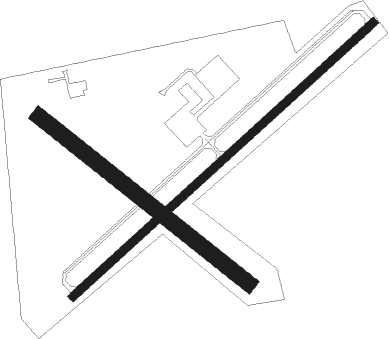
Runway info
Runway 6 / 24  | ||
| length | 1127m (3698ft) | |
| bearing | 55° / 235° | |
| width | 23m (75ft) | |
| surface | asphalt | |
| Runway 13 / 31 | ||
| length | 740m (2428ft) | |
| bearing | 130° / 310° | |
| width | 43m (140ft) | |
| surface | grass | |
| displ threshold | 236m (774ft) / 236m (774ft) | |
Nearby beacons
| code | identifier | dist | bearing | frequency |
|---|---|---|---|---|
| PGD | PUNTA GORDA VOR | 18.6 | 209° | 110.20 |
| LBV | LA BELLE VORTAC | 32.4 | 129° | 110.40 |
| RSW | LEE COUNTY (FORT MYERS) VORTAC | 40.1 | 175° | 111.80 |
| SRQ | SARASOTA VOR/DME | 40.7 | 286° | 117 |
| FM | CALOO (FORT MYERS) NDB | 41.2 | 189° | 341 |
| LAL | LAKELAND VORTAC | 48.4 | 347° | 116 |
| MCF | MACDILL (TAMPA) TACAN | 53.8 | 315° | 111 |
| PIE | SAINT PETERSBURG VORTAC | 62.1 | 310° | 116.40 |
| TP | COSME (TAMPA) NDB | 64.7 | 322° | 368 |
| PI | CAPOK(ST PETERSBURG-CLEARWATER NDB | 66.5 | 313° | 360 |
Instrument approach procedures
| runway | airway (heading) | route (dist, bearing) |
|---|---|---|
| RWNVA | WOMRI (55°) | WOMRI 2000ft |
| RNAV | WOMRI 2000ft ZISMU (4mi, 55°) 1700ft VUYUY (3mi, 55°) 720ft X06 (2mi, 55°) 100ft (4969mi, 108°) 1400ft ROGAN (4973mi, 288°) 2000ft ROGAN (turn) | |
| RWNVB | CAXOB (235°) | CAXOB 2000ft |
| RNAV | CAXOB 2000ft YIDUN (4mi, 236°) 1700ft OYIVO (3mi, 235°) 740ft X06 (2mi, 235°) 103ft (4969mi, 108°) 1400ft ROGAN (4973mi, 288°) 2000ft ROGAN (turn) |
Disclaimer
The information on this website is not for real aviation. Use this data with the X-Plane flight simulator only! Data taken with kind consent from X-Plane 12 source code and data files. Content is subject to change without notice.