Doniphan - Doniphan Muni
Airport details
| Country | United States of America |
| State | Missouri |
| Region | |
| Airspace | Memphis Ctr |
| Municipality | Ripley County |
| Elevation | 634ft (193m) |
| Timezone | GMT -6 |
| Coordinates | 36.69284, -90.78870 |
| Magnetic var | |
| Type | land |
| Available since | X-Plane v10.40 |
| ICAO code | X33 |
| IATA code | n/a |
| FAA code | X33 |
Communication
Nearby Points of Interest:
Randolph Columbus Barrett House
-Ripley County Courthouse
-Ripley County Jail, Sheriff's Office and Sheriff's Residence
-Hillyard Cabin
-Big Spring Historic District
-Alfred W. Greer House
-Williams-Gierth House
-John Archibald Phillips House
-St. Louis-San Francisco Railroad Depot
-Wright-Dalton-Bell-Anchor Department Store Building
-Thomas Moore House
-Rodgers Theatre
-Moore-Dalton House
-Butler County Courthouse
-Oliver House
-Sheeks House
-J. Herbert Moore House
-Cedar Grove School No. 81
-Rice-Upshaw House
-Looney-French House
-Pocahontas Post Office
-Old Randolph County Courthouse
-Randolph County Courthouse
-Greer Spring
-Black River Bridge
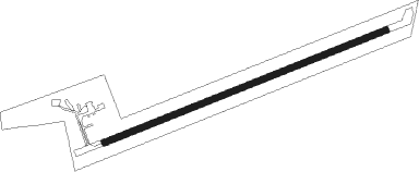
Runway info
| Runway 7 / 25 | ||
| length | 781m (2562ft) | |
| bearing | 76° / 256° | |
| width | 17m (57ft) | |
| surface | asphalt | |
Nearby beacons
| code | identifier | dist | bearing | frequency |
|---|---|---|---|---|
| TNZ | LAWRENCE COUNTY (WALNUT RIDGE) NDB | 29.8 | 195° | 227 |
| ARG | WALNUT RIDGE VORTAC | 35.8 | 196° | 114.50 |
| MAW | MALDEN VORTAC | 43 | 99° | 111.20 |
| JBR | JONESBORO VOR/DME | 50 | 166° | 108.60 |
| FAM | FARMINGTON VORTAC | 64.5 | 29° | 115.70 |
| MAP | MAPLES TACAN | 72.1 | 312° | 113.40 |
Disclaimer
The information on this website is not for real aviation. Use this data with the X-Plane flight simulator only! Data taken with kind consent from X-Plane 12 source code and data files. Content is subject to change without notice.