Dinnet - Aboyne
Airport details
| Country | United Kingdom |
| State | Scotland |
| Region | |
| Airspace | Scottish Ctr |
| Municipality | Aberdeenshire |
| Elevation | 458ft (140m) |
| Timezone | GMT +0 |
| Coordinates | 57.07463, -2.83992 |
| Magnetic var | |
| Type | land |
| Available since | X-Plane v10.30 |
| ICAO code | X6AB |
| IATA code | n/a |
| FAA code | n/a |
Communication
Nearby Points of Interest:
Aboyne, Rhu-na-haven Road, Rhu-na-haven
-Coull Castle
-Muir of Dinnet
-Culsh Earth House
-Birse Castle
-Corse Castle
-Kincardine Castle
-Mains Of Hallhead
-Finzean, Bucket Mill
-Bridge Of Potarch
-Finzean Sawmill And Turning Mill
-Polhollick, Suspension Bridge
-Tarfside, St Droston's Episcopal Church
-Invermark Lodge
-Kildrummy Parish Church
-Glen O'Dee Hospital
-Gairnshiel Lodge, Bridge
-Bridge Wood, Water Of Dye, Bridge Of Dye
-Kirkton Of Glenbuchat, Church
-Raemoir Hotel, Raemoir Hotel Annex
-Midmar Castle
-Terpersie Castle
-Old Keig
-Cluny, Old Churchyard
-Cluny Castle
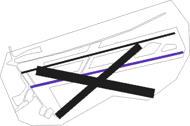
Runway info
Runway 09L / 27R  | ||
| length | 523m (1716ft) | |
| bearing | 84° / 264° | |
| width | 5m (16ft) | |
| surface | asphalt | |
| displ threshold | 60m (197ft) / 61m (200ft) | |
| Runway 09R / 27L | ||
| length | 516m (1693ft) | |
| bearing | 85° / 265° | |
| width | 6m (20ft) | |
| surface | asphalt | |
| displ threshold | 44m (144ft) / 62m (203ft) | |
| Runway 12 / 30 | ||
| length | 368m (1207ft) | |
| bearing | 99° / 279° | |
| width | 30m (98ft) | |
| surface | grass | |
| Runway 05 / 23 | ||
| length | 338m (1109ft) | |
| bearing | 69° / 249° | |
| width | 23m (75ft) | |
| surface | grass | |
Nearby beacons
| code | identifier | dist | bearing | frequency |
|---|---|---|---|---|
| ADN | ABERDEEN VOR/DME | 23.4 | 68° | 114.30 |
| ATF | DYCE (ABERDEEN) NDB | 23.9 | 90° | 348 |
| DND | DUNDEE NDB | 38.2 | 204° | 394 |
| LSM | LOSSIEMOUTH TACAN | 41.3 | 323° | 111.30 |
| PTH | PERTH VOR | 41.7 | 220° | 110.40 |
| LUK | LEUCHARS TACAN | 42.1 | 182° | 110.50 |
Disclaimer
The information on this website is not for real aviation. Use this data with the X-Plane flight simulator only! Data taken with kind consent from X-Plane 12 source code and data files. Content is subject to change without notice.