Arthur East - Arthur Walter's Field
Airport details
| Country | Canada |
| State | Ontario |
| Region | CY |
| Airspace | Toronto Ctr |
| Municipality | Wellington North |
| Elevation | 0ft (0m) |
| Timezone | GMT -5 |
| Coordinates | 43.85000, -80.45000 |
| Magnetic var | |
| Type | land |
| Available since | X-Plane v11.40 |
| ICAO code | XC006M |
| IATA code | n/a |
| FAA code | n/a |
Communication
Nearby Points of Interest:
Wellington County House of Industry and Refuge
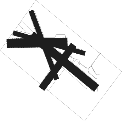
Runway info
Runway 09 / 27  | ||
| length | 580m (1903ft) | |
| bearing | 93° / 273° | |
| width | 101m (330ft) | |
| surface | grass | |
| Runway 04 / 22 | ||
| length | 534m (1752ft) | |
| bearing | 50° / 230° | |
| width | 76m (250ft) | |
| surface | grass | |
| Runway 11 / 29 | ||
| length | 788m (2585ft) | |
| bearing | 105° / 285° | |
| width | 50m (164ft) | |
| surface | grass | |
| Runway 13 / 31 | ||
| length | 856m (2808ft) | |
| bearing | 125° / 305° | |
| width | 91m (300ft) | |
| surface | grass | |
| Runway 16 / 34 | ||
| length | 775m (2543ft) | |
| bearing | 158° / 338° | |
| width | 52m (170ft) | |
| surface | grass | |
Nearby beacons
| code | identifier | dist | bearing | frequency |
|---|---|---|---|---|
| YMS | MANS (MANSFIELD) VOR/DME | 21.9 | 46° | 114.50 |
| ZKF | WELLINGTON (KITCHENER) NDB | 22.5 | 155° | 335 |
| WT | (KITCHENER) DME | 23.7 | 170° | 115 |
| ZTO | WOODHILL (TORONTO) NDB | 33 | 98° | 403 |
| YTP | PEARSON (TORONTO) VOR/DME | 35.7 | 103° | 116.55 |
| YYZ | TORONTO VOR/DME | 37.3 | 103° | 112.15 |
| ZYZ | QUEENSWAY (TORONTO) NDB | 41.5 | 104° | 368 |
| ZHA | ANCASTER (HAMILTON) NDB | 43.3 | 147° | 397 |
| FD | BRANTFORD NDB | 46.6 | 178° | 207 |
| HM | HAMILTON NDB | 47.8 | 149° | 221 |
| ZHM | BINBROOK (HAMILTON) NDB | 51.1 | 137° | 266 |
| YEE | MIDLAND VOR/DME | 52.2 | 42° | 112.80 |
| YXU | LONDON VOR/DME | 57.5 | 221° | 117.20 |
| YVV | WIARTON VOR/DME | 60.6 | 324° | 117.70 |
Disclaimer
The information on this website is not for real aviation. Use this data with the X-Plane flight simulator only! Data taken with kind consent from X-Plane 12 source code and data files. Content is subject to change without notice.