Beausejour - Airliner Drive-in
Airport details
| Country | Canada |
| State | Manitoba |
| Region | |
| Airspace | Winnipeg Ctr |
| Municipality | Rural Municipality of Brokenhead |
| Elevation | 804ft (245m) |
| Timezone | GMT -6 |
| Coordinates | 50.06571, -96.52671 |
| Magnetic var | |
| Type | land |
| Available since | X-Plane v10.30 |
| ICAO code | XC006V |
| IATA code | n/a |
| FAA code | n/a |
Communication
Nearby Points of Interest:
Red River Floodway
-Oak Hammock Marsh
-Ukrainian Labour Temple
-St. Vital Historical Society
-The Forks, Winnipeg
-Confederation Building
-Union Bank Building
-Birks Building
-Burton Cummings Theatre
-Metropolitan Theatre
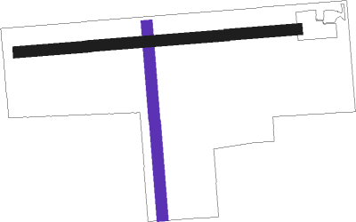
Runway info
| Runway 18 / 36 | ||
| length | 567m (1860ft) | |
| bearing | 180° / 360° | |
| width | 34m (110ft) | |
| surface | grass | |
| displ threshold | 74m (243ft) / 28m (92ft) | |
Runway 09 / 27  | ||
| length | 830m (2723ft) | |
| bearing | 90° / 270° | |
| width | 34m (110ft) | |
| surface | grass | |
| blast zone | 42m (138ft) / 47m (154ft) | |
Nearby beacons
| code | identifier | dist | bearing | frequency |
|---|---|---|---|---|
| ZWG | STONEY (WINNIPEG) NDB | 27.1 | 264° | 287 |
| ZHT | FORKS (WINNIPEG) NDB | 27.6 | 249° | 236 |
| YWG | WINNIPEG VORTAC | 28.7 | 259° | 115.50 |
| BM | BALMORAL NDB | 30.4 | 275° | 375 |
| ZWN | DOWNS (WINNIPEG) NDB | 31.2 | 263° | 201 |
| ZWW | BOINE (WINNIPEG) NDB | 31.5 | 252° | 215 |
| WG | WINNIPEG NDB | 33.3 | 259° | 248 |
| LF | LA SALLE NDB | 39.2 | 241° | 336 |
| M4 | GIMLI NDB | 39.9 | 318° | 296 |
Disclaimer
The information on this website is not for real aviation. Use this data with the X-Plane flight simulator only! Data taken with kind consent from X-Plane 12 source code and data files. Content is subject to change without notice.