Newtonville - Newtonville Steeves Field
Airport details
| Country | Canada |
| State | Ontario |
| Region | |
| Airspace | Toronto Ctr |
| Municipality | Port Hope |
| Elevation | 500ft (152m) |
| Timezone | GMT -5 |
| Coordinates | 43.94004, -78.44515 |
| Magnetic var | |
| Type | land |
| Available since | X-Plane v10.40 |
| ICAO code | XC007Y |
| IATA code | CNT |
| FAA code | n/a |
Communication
Nearby Points of Interest:
George Manning Furby House
-Cream of Barley Mill
-Victoria Hall
-Whitby Junction station
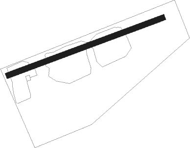
Runway info
| Runway 07 / 25 | ||
| length | 617m (2024ft) | |
| bearing | 78° / 258° | |
| width | 21m (70ft) | |
| surface | grass | |
Nearby beacons
| code | identifier | dist | bearing | frequency |
|---|---|---|---|---|
| YPQ | PETERBOROUGH NDB | 16.3 | 356° | 379 |
| YO | DME-ILS | 19 | 267° | 111.35 |
| OO | OSHAWA NDB | 19.7 | 268° | 391 |
| ZZR | SEVERN (TRENTON) NDB | 36 | 82° | 317 |
| YSO | DME | 36.1 | 292° | 117.35 |
| KZ | BUTTONVILLE NDB | 38.2 | 270° | 248 |
| YCF | DME | 39.6 | 62° | 113.50 |
| UTR | TRENTON TACAN | 41 | 79° | 109.70 |
| TZ | GIBRALTAR POINT NDB | 45.2 | 251° | 257 |
| VIE | COEHILL VOR/DME | 49.4 | 38° | 115.10 |
| IA | KATHI (NIAGRA FALLS) NDB | 52.7 | 205° | 329 |
| IAG | NIAGARA FALLS TACAN | 54.5 | 212° | 111 |
| BU | KLUMP (BUFFALO) NDB | 57.1 | 192° | 231 |
| SN | ST CATHARINES NDB | 59.2 | 226° | 408 |
| ROC | ROCHESTER VOR/DME | 59.7 | 137° | 110 |
Disclaimer
The information on this website is not for real aviation. Use this data with the X-Plane flight simulator only! Data taken with kind consent from X-Plane 12 source code and data files. Content is subject to change without notice.