Port Perry - Port Perry Hoskin Field
Airport details
| Country | Canada |
| State | Ontario |
| Region | CY |
| Airspace | Toronto Ctr |
| Municipality | Scugog |
| Elevation | 899ft (274m) |
| Timezone | GMT -5 |
| Coordinates | 44.06167, -78.88528 |
| Magnetic var | |
| Type | land |
| Available since | X-Plane v10.40 |
| ICAO code | XC0088 |
| IATA code | n/a |
| FAA code | n/a |
Communication
Nearby Points of Interest:
Uxbridge railway station
-Whitby Junction station
-Cream of Barley Mill
-Lebovic Centre for Arts & Entertainment – Nineteen on the Park
-Bead Hill archaeological site
-Markham Village Town Hall
-Markham Civic Centre
-Taber Hill
-Richmond Hill railway station
-Queensville Radial Station
-Old Newmarket Town Hall and Courthouse
-Newmarket Railway Station
-Sutton radial station
-The Briars
-George Manning Furby House
-David Dunlap Observatory
-Shift
-George Davis House
-Government of Canada Building
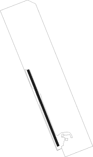
Runway info
| Runway 16 / 34 | ||
| length | 670m (2198ft) | |
| bearing | 157° / 337° | |
| width | 18m (60ft) | |
| surface | grass | |
Nearby beacons
| code | identifier | dist | bearing | frequency |
|---|---|---|---|---|
| OO | OSHAWA NDB | 8.4 | 186° | 391 |
| YO | DME-ILS | 8.5 | 180° | 111.35 |
| YSO | DME | 16.2 | 302° | 117.35 |
| YPQ | PETERBOROUGH NDB | 20.3 | 70° | 379 |
| KZ | BUTTONVILLE NDB | 20.6 | 254° | 248 |
| TZ | GIBRALTAR POINT NDB | 34.5 | 228° | 257 |
| ZYZ | QUEENSWAY (TORONTO) NDB | 39 | 236° | 368 |
| YYZ | TORONTO VOR/DME | 40.3 | 242° | 112.15 |
| ZTO | WOODHILL (TORONTO) NDB | 40.3 | 248° | 403 |
| YTP | PEARSON (TORONTO) VOR/DME | 41 | 243° | 116.55 |
| YEE | MIDLAND VOR/DME | 49.9 | 300° | 112.80 |
| VIE | COEHILL VOR/DME | 55.9 | 59° | 115.10 |
| IAG | NIAGARA FALLS TACAN | 57 | 185° | 111 |
| IA | KATHI (NIAGRA FALLS) NDB | 57.2 | 177° | 329 |
| SN | ST CATHARINES NDB | 57.2 | 202° | 408 |
| ZHM | BINBROOK (HAMILTON) NDB | 67.7 | 225° | 266 |
Disclaimer
The information on this website is not for real aviation. Use this data with the X-Plane flight simulator only! Data taken with kind consent from X-Plane 12 source code and data files. Content is subject to change without notice.