Plevna - Plevna Tomvale
Airport details
| Country | Canada |
| State | Ontario |
| Region | CY |
| Airspace | Toronto Ctr |
| Municipality | North Frontenac |
| Elevation | 890ft (271m) |
| Timezone | GMT -5 |
| Coordinates | 44.91764, -76.93887 |
| Magnetic var | |
| Type | land |
| Available since | X-Plane v10.40 |
| ICAO code | XC008T |
| IATA code | n/a |
| FAA code | n/a |
Communication
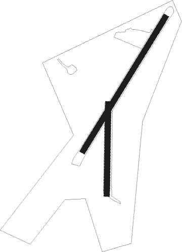
Runway info
Runway 03 / 21  | ||
| length | 638m (2093ft) | |
| bearing | 46° / 226° | |
| width | 23m (75ft) | |
| surface | asphalt | |
| Runway 01 / 19 | ||
| length | 366m (1201ft) | |
| bearing | 8° / 188° | |
| width | 23m (75ft) | |
| surface | grass | |
Nearby beacons
| code | identifier | dist | bearing | frequency |
|---|---|---|---|---|
| YGK | KINGSTON NDB | 39.9 | 152° | 263 |
| VIE | COEHILL VOR/DME | 43.2 | 255° | 115.10 |
| YTR | TRENTON NDB | 47.8 | 213° | 215 |
| YCF | DME | 47.9 | 233° | 113.50 |
| YXI | DME | 52.8 | 318° | 115.60 |
| UTR | TRENTON TACAN | 54 | 217° | 109.70 |
| YTA | PEMBROKE NDB | 54.4 | 342° | 409 |
| ZZR | SEVERN (TRENTON) NDB | 59.7 | 218° | 317 |
| YWA | PETAWAWA NDB | 60.3 | 341° | 516 |
| ART | WATERTOWN VORTAC | 69 | 138° | 109.80 |
Disclaimer
The information on this website is not for real aviation. Use this data with the X-Plane flight simulator only! Data taken with kind consent from X-Plane 12 source code and data files. Content is subject to change without notice.