The Pas - The Pas Grace Lake
Airport details
| Country | Canada |
| State | Manitoba |
| Region | CY |
| Airspace | Winnipeg Ctr |
| Municipality | The Pas |
| Elevation | 873ft (266m) |
| Timezone | GMT -6 |
| Coordinates | 53.82647, -101.20533 |
| Magnetic var | |
| Type | land |
| Available since | X-Plane v10.40 |
| ICAO code | XCJR3 |
| IATA code | n/a |
| FAA code | n/a |
Communication
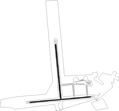
Runway info
Runway 08 / 26  | ||
| length | 993m (3258ft) | |
| bearing | 90° / 270° | |
| width | 15m (50ft) | |
| surface | gravel | |
| blast zone | 52m (171ft) / 66m (217ft) | |
| Runway 17 / 35 | ||
| length | 869m (2851ft) | |
| bearing | 179° / 359° | |
| width | 20m (65ft) | |
| surface | gravel | |
| blast zone | 78m (256ft) / 0m (0ft) | |
Nearby beacons
| code | identifier | dist | bearing | frequency |
|---|---|---|---|---|
| YQD | THE PAS VOR/DME | 9.5 | 36° | 113.60 |
| QD | THE PAS NDB | 10.1 | 39° | 284 |
| FO | FLIN FLON NDB | 53.4 | 331° | 250 |
Disclaimer
The information on this website is not for real aviation. Use this data with the X-Plane flight simulator only! Data taken with kind consent from X-Plane 12 source code and data files. Content is subject to change without notice.