Hülben - Huelben_segelflug
Airport details
| Country | Germany |
| State | Baden-Württemberg |
| Region | |
| Airspace | Langen Ctr |
| Municipality | Hülben |
| Elevation | 2358ft (719m) |
| Timezone | GMT +1 |
| Coordinates | 48.52973, 9.39701 |
| Magnetic var | |
| Type | land |
| Available since | X-Plane v10.40 |
| ICAO code | XED05 |
| IATA code | n/a |
| FAA code | n/a |
Communication
| Huelben_Segelflug Huelben | 119.730 |
Nearby Points of Interest:
Stift Urach
-Haus auf der Alb
-Motorworld Manufaktur Metzingen
-Alte Feuerwache (Reutlingen)
-Stadtmauer Grötzingen
-Altes Lager Münsingen
-Gutenhalde
-Deffnerstraße 6/1
-Neckarstraße 65
-Neckarstraße 46
-Obertorstraße 42,44,46
-Haus Obertorstraße 21/23
-Kanalstraße 12/1
-Entengrabenstraße 2
-Neuer Jüdischer Friedhof
-Alte Feuerwache (Esslingen)
-Gasthof zum Falken
-Innere Brücke 26
-Central-Theater
-Landolinsgasse 8/1
-Glasdachfabrik Eberspächer
-Zwerchstraße 6
-Fleischmannstraße 10
-Hafenmarkt 7
-Berliner Straße 17 (Esslingen)
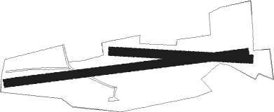
Runway info
Runway 11 / 29  | ||
| length | 387m (1270ft) | |
| bearing | 95° / 275° | |
| width | 24m (78ft) | |
| surface | grass | |
| Runway 08 / 26 | ||
| length | 679m (2228ft) | |
| bearing | 88° / 268° | |
| width | 23m (76ft) | |
| surface | grass | |
Nearby beacons
| code | identifier | dist | bearing | frequency |
|---|---|---|---|---|
| TGO | TANGO TACAN | 7.6 | 303° | 112.50 |
| STG | STUTTGART VOR/DME | 11.4 | 320° | 116.85 |
| SGD | DME | 11.7 | 312° | 115.45 |
| LBU | LUBURG VOR/DME | 23.1 | 352° | 109.20 |
| LUP | LAUPHEIM NDB | 27.7 | 121° | 407 |
| SUL | SULZ VOR | 31.2 | 259° | 116.10 |
| SHD | HALL DME | 38.3 | 33° | 108.05 |
| KRH | KARLSRUHE VOR/DME | 42.5 | 300° | 115.95 |
| ALD | (MEMMINGEN/ALLGAU) DME | 46.5 | 123° | 117.20 |
| ALG | ALLGAEU (MEMMINGEN) NDB | 47.1 | 122° | 341 |
| DKB | DINKELSBUEHL VORTAC | 49.6 | 54° | 117.80 |
| FHD | DME | 51.9 | 173° | 112.60 |
| NKR | NECKAR NDB | 55 | 321° | 292 |
| NDD | DME-ILS | 56.4 | 33° | 108.70 |
| NSN | NIEDERSTETTEN NDB | 56.5 | 33° | 311 |
| KPT | KEMPTEN VOR/DME | 60.6 | 129° | 108.40 |
| ZUE | ZURICH EAST VOR/DME | 60.9 | 212° | 110.05 |
| TRA | DME | 63.4 | 229° | 114.30 |
| MND | DME | 66.3 | 317° | 113.55 |
| ILM | ILLESHEIM NDB | 68.7 | 46° | 488 |
Disclaimer
The information on this website is not for real aviation. Use this data with the X-Plane flight simulator only! Data taken with kind consent from X-Plane 12 source code and data files. Content is subject to change without notice.