Wutöschingen - Bohlhof
Airport details
| Country | Germany |
| State | Baden-Württemberg |
| Region | |
| Airspace | Switzerland Ctr |
| Municipality | Wutöschingen |
| Elevation | 1867ft (569m) |
| Timezone | GMT +1 |
| Coordinates | 47.64702, 8.38386 |
| Magnetic var | |
| Type | land |
| Available since | X-Plane v11.55 |
| ICAO code | XEDA3 |
| IATA code | n/a |
| FAA code | n/a |
Communication
| Bohlhof Bohlhof Info | 118.435 |
Nearby Points of Interest:
St. Johannes
-St.-Gallus-Kapelle (Raßbach)
-Burg Untermettingen
-Ölmühle Tiengen
-Marschallhaus
-castle (former villa Zuberbühler)
-late Roman double fort together with "Sidelen" and early Christian church ground plan with baptismal font
-Engelburg
-Provostry Wislikofen
-Kleiner Laufen, part of the late Roman Rhine fortifications
-former provostry of St. Blasien monastry
-Iuliomagus
-Eglisau Castle
-Klingnauer Stausee
-railroad viaduct Koblenz-Felsenau
-Kapuzinerkloster Waldshut
-Rheinau
-Loreto chapel
-Rheinau Abbey
-Berg am Irchel
-Bülach
-Sonnenburggut
-Flaach
-Aquae Helveticae, Roman vicus / medieval / modern city
-Werksiedlung Stahlwerkstrasse
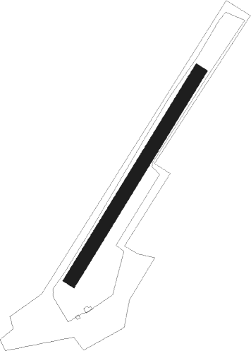
Runway info
| Runway 04 / 22 | ||
| length | 657m (2156ft) | |
| bearing | 47° / 227° | |
| width | 36m (118ft) | |
| surface | grass | |
| blast zone | 0m (0ft) / 150m (492ft) | |
Nearby beacons
| code | identifier | dist | bearing | frequency |
|---|---|---|---|---|
| TRA | DME | 3.3 | 51° | 114.30 |
| KLO | KLOTEN (ZURICH) VOR/DME | 13.1 | 140° | 114.85 |
| ZUE | ZURICH EAST VOR/DME | 17.8 | 97° | 110.05 |
| HOC | DME | 31 | 256° | 113.20 |
| WIL | WILLISAU VOR/DME | 34.2 | 226° | 116.90 |
| BS | BASLE-MULHOUSE NDB | 34.5 | 265° | 376 |
| BLM | BASLE-MULHOUSE VOR/DME | 35.7 | 269° | 117.45 |
| BN | BASLE-MULHOUSE NDB | 36.6 | 271° | 353 |
| SUL | SULZ VOR | 45.3 | 20° | 116.10 |
| LHR | LAHR NDB | 48 | 321° | 337 |
| GRE | GRENCHEN VOR/DME | 48.1 | 244° | 115.45 |
| LRD | DME | 48.5 | 322° | 108.05 |
| STR | STRASBOURG ENTZHEIM VOR/DME | 60.9 | 317° | 115.60 |
| SE | STRASBOURG NDB | 62.6 | 325° | 412 |
| TGO | TANGO TACAN | 68 | 42° | 112.50 |
Disclaimer
The information on this website is not for real aviation. Use this data with the X-Plane flight simulator only! Data taken with kind consent from X-Plane 12 source code and data files. Content is subject to change without notice.