Freudental - Loechgau
Airport details
| Country | Germany |
| State | Baden-Württemberg |
| Region | |
| Airspace | Langen Ctr |
| Municipality | Löchgau |
| Elevation | 875ft (267m) |
| Timezone | GMT +1 |
| Coordinates | 49.00066, 9.07956 |
| Magnetic var | |
| Type | land |
| Available since | X-Plane v10.40 |
| ICAO code | XEDD2 |
| IATA code | n/a |
| FAA code | n/a |
Communication
| Loechgau Loechgau Info | 131.005 |
Nearby Points of Interest:
Schloss Großsachsenheim
-Burg Bönnigheim
-Kastelle von Walheim
-Georgskirche (Hausen an der Zaber)
-Rathaus Ottmarsheim
-Altes Rathaus (Güglingen)
-Pleidelsheim power station
-Altes Rathaus (Dürrenzimmern)
-Maria-Magdalenen-Kirche
-Alte Kelter
-Zehnthaus
-Rathaus Markgröningen
-Altes Pfarrhaus
-Monrepos
-Lämlinhaus
-Oberes Schloss (Talheim)
-Unteres Schloss
-Posthof Illingen
-Old parsonage
-Bruckmühle
-Waldhorn
-Marktbrunnen
-Pflugfelder Straße 5
-Evangelisches Pfarrhaus
-Pflugfelder Straße 20
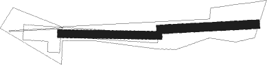
Runway info
Runway 10 / 28  | ||
| length | 409m (1342ft) | |
| bearing | 94° / 274° | |
| width | 33m (108ft) | |
| surface | grass | |
| Runway 09 / 27 | ||
| length | 401m (1316ft) | |
| bearing | 91° / 271° | |
| width | 37m (121ft) | |
| surface | grass | |
Nearby beacons
| code | identifier | dist | bearing | frequency |
|---|---|---|---|---|
| LBU | LUBURG VOR/DME | 11.5 | 109° | 109.20 |
| KRH | KARLSRUHE VOR/DME | 19.5 | 269° | 115.95 |
| STG | STUTTGART VOR/DME | 19.5 | 150° | 116.85 |
| SGD | DME | 19.6 | 155° | 115.45 |
| TGO | TANGO TACAN | 24 | 155° | 112.50 |
| NKR | NECKAR NDB | 24.3 | 314° | 292 |
| SHD | HALL DME | 28.3 | 81° | 108.05 |
| MND | DME | 35.8 | 310° | 113.55 |
| KBA | KARLSRUHE/BADEN-BADEN NDB | 40.6 | 258° | 431 |
| SUL | SULZ VOR | 40.9 | 215° | 116.10 |
| KBD | DME | 41.3 | 257° | 115.80 |
| NDD | DME-ILS | 41.8 | 66° | 108.70 |
| NSN | NIEDERSTETTEN NDB | 42 | 66° | 311 |
| RID | RIED VOR/DME | 51.4 | 325° | 112.20 |
| CHA | CHARLIE VOR/DME | 55.3 | 358° | 115.35 |
| LUP | LAUPHEIM NDB | 57.4 | 133° | 407 |
| VFM | NAUHEIM VOR | 62.4 | 328° | 113.75 |
Disclaimer
The information on this website is not for real aviation. Use this data with the X-Plane flight simulator only! Data taken with kind consent from X-Plane 12 source code and data files. Content is subject to change without notice.