Airports for X-Plane offers a convenient way to explore airports and their related communication information for the X-Plane flight simulator. It only uses data from the X-Plane flight simulator itself, and is therefore more reliable than the data that comes from real aviation websites. You can search for airports by using the ICAO code, or browse for airports per country and state. The information displayed is categorized by airport details, runway information, airport communication, approach frequencies (ILS and Glidepath details), details of nearby beacons, SIDs, STARs and approach procedures.

airport authority hospital rail warfare train flight attendant airfield road non-towered airport control tower automated airport weather station airspace aviation plane jet airdock airliner airdrome airplane government

Fulda Railway Station - Fulda Johannisau

Airport details

CountryGermany
StateHesse
Region
AirspaceLangen Ctr
MunicipalityFulda
Elevation818ft (249m)
TimezoneGMT +1
Coordinates50.53584, 9.65998
Magnetic var
Typeland
Available sinceX-Plane v10.40
ICAO codeXEDDD
IATA coden/a
FAA coden/a

Communication

Fulda JohannisAu Johannisau Start125.385
Nearby Points of Interest:
Propstei Johannesberg
-
Fulda
-
Palais Altenstein
-
Richthalle Fulda
-
Saint Joseph Chapel
-
Jagdschloss Giesel
-
Kriegerdenkmal
-
Church of the Assumption
-
Heilig Kreuz
-
Kloster Blankenau
-
Synagoge Flieden
-
St. Vitus
-
Saint Mary Chapel (Jossa, Hosenfeld)
-
Evangelische Kirche Schlotzau
-
Jewish cemetery, Burghaun
-
Eisenbacher Straße 1
-
Evangelische Kirche Altenschlirf
-
Wallfahrtskirche
-
Pfarrkirche
-
Naxburg
-
Eisenbahnbrücke (Frischborn)
-
Filialkirche
-
Am Eichberg 37
-
Am Eichberg 41
-
Stadtkirche Lauterbach

Runway info

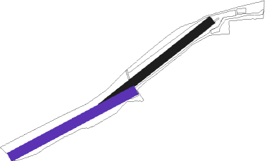
Runway 05 / 23  
 length451m (1480ft)
 bearing67° / 247°
 width27m (89ft)
 surfacegrass
Runway 06 / 24
 length450m (1476ft)
 bearing75° / 255°
 width30m (100ft)
 surfacegrass

Airport layout - runway 06 / 24


Parking locations

Nearby beacons

codeidentifierdistbearingfrequency
FULFULDA VOR/DME4.7303°112.10
GEDGEDERN VORTAC17.3253°110.80
FTZFRITZLAR NDB34.2336°468
MTRMETRO VOR34.7252°110
CHACHARLIE VOR/DME43.9225°115.35
FRFRANKFURT NDB46.9244°297
DKSDME-ILS54344°111.50
WRBWARBURG VOR/DME61.8330°113.70

Disclaimer

The information on this website is not for real aviation. Use this data with the X-Plane flight simulator only! Data taken with kind consent from X-Plane 12 source code and data files. Content is subject to change without notice.