Paddock Wood - Laddingford Aerodrome
Airport details
| Country | United Kingdom |
| State | England |
| Region | |
| Airspace | London Ctr |
| Municipality | Maidstone |
| Elevation | 40ft (12m) |
| Timezone | GMT +0 |
| Coordinates | 51.19085, 0.41024 |
| Magnetic var | |
| Type | land |
| Available since | X-Plane v10.40 |
| ICAO code | XEG002C |
| IATA code | n/a |
| FAA code | n/a |
Communication
| Laddingford Aerodrome Safetycom | 135.480 |
Nearby Points of Interest:
St Michael's Church, East Peckham
-Teston Bridge
-Barham Court
-Somerhill House
-Oxon Hoath
-Boughton Monchelsea Place
-Pattyndenne Manor
-Fairlawne
-College of All Saints, Maidstone
-Tithe Barn, Maidstone
-Maidstone Town Hall
-Tunbridge Wells Town Hall
-Queen's Own Royal West Kent Regiment Cenotaph
-The Old Sessions House
-Bidborough Windmill
-Rehoboth Chapel, Pell Green
-Oldbury hillfort
-Boxley Abbey Barn
-High Rocks
-Wadhurst Castle
-St Benedict's Church, Paddlesworth
-St Mary's Church, Burham
-Eridge Park
-Shover's Green Baptist Chapel
-Knole Park
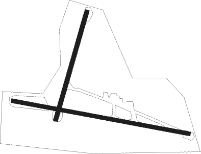
Runway info
Runway 03 / 21  | ||
| length | 455m (1493ft) | |
| bearing | 31° / 211° | |
| width | 18m (60ft) | |
| surface | grass | |
| Runway 11 / 29 | ||
| length | 734m (2408ft) | |
| bearing | 100° / 280° | |
| width | 15m (50ft) | |
| surface | grass | |
Nearby beacons
| code | identifier | dist | bearing | frequency |
|---|---|---|---|---|
| HLS | DME | 9.3 | 99° | 115.95 |
| LSH | HEADCORN (LASHENDEN) NDB | 9.3 | 99° | 340 |
| DET | DETLING VOR/DME | 9.7 | 59° | 117.30 |
| MAY | MAYFIELD VOR/DME | 15.2 | 239° | 117.90 |
| BIG | BIGGIN VOR/DME | 16.4 | 290° | 115.10 |
| LYD | LYDD VOR/DME | 21 | 112° | 114.05 |
| LCY | LONDON CITY NDB | 22.7 | 312° | 322 |
| LZD | LYDD NDB | 24.3 | 114° | 397 |
| SND | SOUTHEND NDB | 25.5 | 37° | 362 |
| SFD | SEAFORD VOR/DME | 28 | 214° | 117 |
| LAM | LAMBOURNE VOR/DME | 29 | 330° | 115.60 |
| EPM | EPSOM NDB | 30.4 | 279° | 316 |
| OCK | OCKHAM VOR/DME | 32.9 | 278° | 115.30 |
| SRH | DME-ILS | 34 | 243° | 109.95 |
| SHM | SHOREHAM NDB | 34.1 | 243° | 332 |
| DVR | DOVER VOR/DME | 35.7 | 92° | 114.95 |
| LON | LONDON VOR/DME | 37.4 | 289° | 113.60 |
| BPK | BROOKMANS PARK VOR/DME | 38.7 | 317° | 117.50 |
| MID | MIDHURST VOR/DME | 39.8 | 262° | 114 |
| CHT | CHILTERN NDB | 43.4 | 295° | 277 |
| BUR | BURNHAM NDB | 45.2 | 287° | 421 |
| BLC | DME | 47.8 | 276° | 116.20 |
| BLK | BLACKBUSHE NDB | 47.8 | 276° | 328 |
| CLN | CLACTON VOR/DME | 48.1 | 48° | 114.55 |
| BNN | BOVINGDON VOR/DME | 48.2 | 299° | 113.75 |
| GWC | GOODWOOD VOR/DME | 48.4 | 254° | 114.75 |
| LUT | LUTON NDB | 48.9 | 317° | 345 |
| BKY | BARKWAY VOR/DME | 49.7 | 336° | 116.25 |
| WOD | WOODLEY NDB | 50.8 | 281° | 352 |
| ODH | ODIHAM TACAN | 51.1 | 272° | 109.60 |
| HEN | HENTON NDB | 56.4 | 295° | 433 |
| WTZ | WATTISHAM TACAN | 59.3 | 30° | 109.30 |
| BSO | BENSON TACAN | 62 | 286° | 110 |
| CPT | COMPTON VOR/DME | 63.7 | 280° | 114.35 |
| WCO | WESTCOTT NDB | 64.8 | 296° | 335 |
| CIT | CRANFIELD NDB | 66.9 | 314° | 850 |
| SAM | SOUTHAMPTON VOR/DME | 67.7 | 262° | 113.35 |
| EAS | SOUTHAMPTON (EASTLEIGH) NDB | 68.1 | 262° | 391 |
Disclaimer
The information on this website is not for real aviation. Use this data with the X-Plane flight simulator only! Data taken with kind consent from X-Plane 12 source code and data files. Content is subject to change without notice.