Rodsley - Darley Moor
Airport details
| Country | United Kingdom |
| State | England |
| Region | |
| Airspace | London Ctr |
| Municipality | Derbyshire Dales |
| Elevation | 586ft (179m) |
| Timezone | GMT +0 |
| Coordinates | 52.96761, -1.75033 |
| Magnetic var | |
| Type | land |
| Available since | X-Plane v10.40 |
| ICAO code | XEG3DM |
| IATA code | n/a |
| FAA code | n/a |
Communication
Nearby Points of Interest:
Yeaveley Preceptory
-Medieval settlement, including site of chapel and part of the open field system, immediately north east of Alkmonton Old Hall Fa
-Okeover Hall
-Ednaston Manor
-Brocksford Hall
-Ilam Park
-Bradbourne Hall
-Radbourne Hall
-Parwich Hall
-Haarlem Mill
-Dovecliff Hall
-Monks Bridge
-Allestree Hall
-Duffield Hall
-Derwent Valley Mills
-Milford Tunnel
-County Hall
-Derby Central Library
-Guildhall Theatre
-Derby Central School of Art
-Burton upon Trent Town Hall
-Old Grammar School
-Repton Priory
-Burton Abbey
-Coxbench Hall
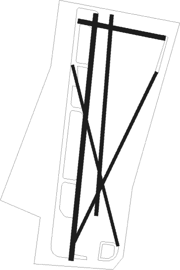
Runway info
Runway 02 / 20  | ||
| length | 641m (2103ft) | |
| bearing | 17° / 197° | |
| width | 13m (41ft) | |
| surface | grass | |
| Runway 01 / 19 | ||
| length | 522m (1713ft) | |
| bearing | 15° / 195° | |
| width | 9m (29ft) | |
| surface | hard surface | |
| Runway 17 / 35 | ||
| length | 485m (1591ft) | |
| bearing | 164° / 344° | |
| width | 8m (25ft) | |
| surface | grass | |
| Runway 11 / 29 | ||
| length | 222m (728ft) | |
| bearing | 100° / 280° | |
| width | 12m (38ft) | |
| surface | grass | |
| Runway 03 / 21 | ||
| length | 498m (1634ft) | |
| bearing | 44° / 224° | |
| width | 8m (25ft) | |
| surface | grass | |
Nearby beacons
| code | identifier | dist | bearing | frequency |
|---|---|---|---|---|
| TNT | TRENT VOR/DME | 5.9 | 43° | 115.70 |
| TNL | TATENHILL NDB | 9.1 | 186° | 327 |
| EMW | EAST MIDLANDS NDB | 13.5 | 115° | 393 |
| EME | EAST MIDLANDS NDB | 21.7 | 104° | 353 |
| MCT | MANCHESTER VOR/DME | 29.7 | 307° | 113.55 |
| BHX | BIRMINGHAM NDB | 30.8 | 180° | 406 |
| WBA | WOLVERHAMPTON NDB | 32.8 | 229° | 356 |
| WOL | DME | 32.8 | 229° | 108.60 |
| LE | LEICESTER NDB | 33.8 | 117° | 383 |
| WHI | WHITEGATE NDB | 34 | 284° | 368 |
| GAM | GAMSTON VOR/DME | 34.5 | 69° | 112.80 |
| SWB | SHAWBURY VOR/DME | 34.5 | 259° | 116.80 |
| HON | HONILEY VOR/DME | 36.8 | 172° | 113.65 |
| FNY | DONCASTER SHEFFIELD NDB | 40.6 | 56° | 338 |
| LPL | LIVERPOOL NDB | 41.6 | 291° | 349 |
| POL | POLE HILL VOR/DME | 48.3 | 336° | 112.10 |
| DTY | DAVENTRY VOR/DME | 52.6 | 141° | 116.40 |
| SBL | SHERBURN-IN-ELMET NDB | 53 | 33° | 323 |
| LBA | LEEDS BRADFORD NDB | 54 | 6° | 402 |
Disclaimer
The information on this website is not for real aviation. Use this data with the X-Plane flight simulator only! Data taken with kind consent from X-Plane 12 source code and data files. Content is subject to change without notice.