Airports for X-Plane offers a convenient way to explore airports and their related communication information for the X-Plane flight simulator. It only uses data from the X-Plane flight simulator itself, and is therefore more reliable than the data that comes from real aviation websites. You can search for airports by using the ICAO code, or browse for airports per country and state. The information displayed is categorized by airport details, runway information, airport communication, approach frequencies (ILS and Glidepath details), details of nearby beacons, SIDs, STARs and approach procedures.

airdrome hotel airborne kennedy automated airport weather station downtown aviation stopover ferry control tower flights airport nation takeoff field airdock airspace air terminal grass hangar

Borne Sulinowo

Airport details

CountryPoland
StateWest Pomeranian Voivodeship
Region
AirspaceWarsaw Ctr
MunicipalityBorne Sulinowo
Elevation466ft (142m)
TimezoneGMT +1
Coordinates53.57598, 16.52574
Magnetic var
Typeland
Available sinceX-Plane v11.05
ICAO codeXEPBS
IATA coden/a
FAA coden/a

Communication

Borne Sulinowo RADIO123.450
Nearby Points of Interest:
Castle of the Pomeranian Dukes in Szczecinek
-
Bismarck tower in Okonek
-
Czaplinek town hall
-
Kościół Podwyższenia Krzyża Świętego w Czaplinku
-
Church of the Ascension of Christ in Łomczewo
-
Saint Stanislaus church in Węgorzewo
-
Kościół Narodzenia Najświętszej Maryi Panny w Karsiborze
-
Zamek w Czarnem
-
Palace in Białowąs
-
Town hall in Wałcz
-
Castle in Złocieniec
-
Kościół św. Jakuba Apostoła w Bronikowie
-
Palace in Darskowo
-
Immaculate Conception church in Mirosławiec
-
Relicts of Mirosławiec Castle
-
Saint Catherine of Alexandria church in Marcinkowice
-
Church of the Assumption of Mary in Bobolice

Runway info

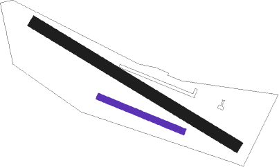
Runway 11 / 29
 length234m (768ft)
 bearing107° / 287°
 width16m (54ft)
 surfaceasphalt
Runway 13 / 31  
 length612m (2008ft)
 bearing113° / 293°
 width30m (99ft)
 surfacegrass

Airport layout - runway 11 / 29


Parking locations

Nearby beacons

codeidentifierdistbearingfrequency
CZADME9253°117
NAMIROSLAWIEC NDB18.8245°297
TMIMIROSLAWIEC TACAN19.3249°115.35
NDSWIDWIN NDB26.8287°280
TSNSWIDWIN TACAN26.9287°116
TZEDME42.741°113.80
TDADARLOWO TACAN50.1349°116.85
DARDARLOWO VOR/DME50.3351°114.20
SDARLOWO NDB50.6349°436
SADARLOWO NDB51.6351°474
DREDME51.9222°115.30

Disclaimer

The information on this website is not for real aviation. Use this data with the X-Plane flight simulator only! Data taken with kind consent from X-Plane 12 source code and data files. Content is subject to change without notice.