Horn - Hornlanda
Airport details
| Country | Sweden |
| State | [Other] |
| Region | |
| Airspace | Sweden Ctr |
| Municipality | Kinda kommun |
| Elevation | 353ft (108m) |
| Timezone | GMT +1 |
| Coordinates | 57.86425, 15.84232 |
| Magnetic var | |
| Type | land |
| Available since | X-Plane v10.40 |
| ICAO code | XESS10 |
| IATA code | n/a |
| FAA code | n/a |
Communication
| Hornlanda Hornlanda RDO | 123.425 |
Nearby Points of Interest:
Horns socken
-Hycklinge socken
-Hycklinge kyrka
-Djursdala socken
-Södra Vi socken
-Locknevi socken
-Lokstallet i Kisa
-Västra Eneby socken
-Kisa kyrka
-Kisa socken
-Oppeby socken
-Rumskulla oak
-Odensvi socken
-Frödinge kyrka
-Frödinge socken
-Tidersrums socken
-Kölefors vaddfabrik
-Vimmerby Church
-Vimmerby Town
-Vimmerby socken
-Blackstad socken
-Hallingebergs socken
-Hägerstads kyrka
-Dalhems socken
-Hägerstads socken
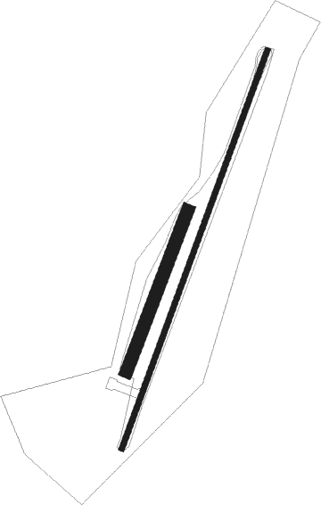
Runway info
Runway 03L / 21R  | ||
| length | 330m (1083ft) | |
| bearing | 42° / 222° | |
| width | 25m (82ft) | |
| surface | grass | |
| Runway 03 / 21 | ||
| length | 816m (2677ft) | |
| bearing | 41° / 221° | |
| width | 10m (33ft) | |
| surface | asphalt | |
| displ threshold | 0m (0ft) / 130m (427ft) | |
Nearby beacons
| code | identifier | dist | bearing | frequency |
|---|---|---|---|---|
| VSN | VASSEN VOR/DME | 26.6 | 343° | 115.25 |
| LCF | MALMEN (LINKOPING) NDB | 29.8 | 321° | 285 |
| OL | SAAB (LINKOPING) NDB | 30.9 | 356° | 415 |
| SC | SAAB (LINKOPING) NDB | 35.3 | 333° | 300 |
| ON | NORRKOPING NDB | 46.4 | 37° | 324 |
| NW | SKAVSTA (STOCKHOLM) NDB | 62.6 | 46° | 364 |
Disclaimer
The information on this website is not for real aviation. Use this data with the X-Plane flight simulator only! Data taken with kind consent from X-Plane 12 source code and data files. Content is subject to change without notice.