Reserve - Negrito Airstrip
Airport details
| Country | United States of America |
| State | New Mexico |
| Region | |
| Airspace | Albuquerque Ctr |
| Municipality | Catron County |
| Elevation | 8142ft (2482m) |
| Timezone | GMT -7 |
| Coordinates | 33.52231, -108.54717 |
| Magnetic var | |
| Type | land |
| Available since | X-Plane v10.40 |
| ICAO code | XK000O |
| IATA code | n/a |
| FAA code | 0NM7 |
Communication
Nearby Points of Interest:
Mogollon Baldy Lookout Cabin
-Cosmic Campground
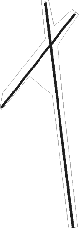
Runway info
Runway 03 / 21  | ||
| length | 1254m (4114ft) | |
| bearing | 48° / 228° | |
| width | 20m (66ft) | |
| surface | gravel | |
| Runway 17 / 35 | ||
| length | 2396m (7861ft) | |
| bearing | 177° / 357° | |
| width | 20m (66ft) | |
| surface | gravel | |
Nearby beacons
| code | identifier | dist | bearing | frequency |
|---|---|---|---|---|
| SVC | SILVER CITY VOR/DME | 56.5 | 156° | 110.80 |
| SV | COZEY (SILVER CITY) NDB | 58.7 | 151° | 251 |
| SJN | ST JOHNS VORTAC | 61.7 | 327° | 112.30 |
Disclaimer
The information on this website is not for real aviation. Use this data with the X-Plane flight simulator only! Data taken with kind consent from X-Plane 12 source code and data files. Content is subject to change without notice.