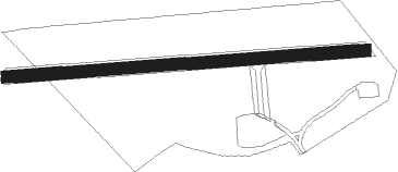
Helena West Side - Duncan
Airport details
| Country | United States of America |
| State | Montana |
| Region | K1 |
| Airspace | Salt Lake City Ctr |
| Municipality | Lewis and Clark County |
| Elevation | 4258ft (1298m) |
| Timezone | GMT -7 |
| Coordinates | 46.57000, -112.17457 |
| Magnetic var | |
| Type | land |
| Available since | X-Plane v10.40 |
| ICAO code | XK0082 |
| IATA code | n/a |
| FAA code | n/a |
Communication
Nearby Points of Interest:
Helena Historic District
-Hauser Mansion
-Olsen House
-Helena Civic Center
-Porter Flats Apartments
-Robert and Elizabeth Fisk House
-Morris Silverman House
-Wick-Seiler House
-Lewis and Clark County Hospital Historic District
-Montana State Capitol
-Montana Veterans and Pioneers Memorial Building
-Forestvale Cemetery
-Kluge House
-W.C. Child Ranch
-Jefferson County Courthouse
-Montana Deaf and Dumb Asylum
-Mann Gulch fire
-Eagle Guard Station
-Deer Lodge American Women's League Chapter House
-Grant-Kohrs Ranch National Historic Site
Runway info
| Runway 09 / 27 | ||
| length | 419m (1375ft) | |
| bearing | 90° / 270° | |
| width | 14m (45ft) | |
| surface | grass | |
Nearby beacons
| code | identifier | dist | bearing | frequency |
|---|---|---|---|---|
| HLN | HELENA VORTAC | 9.3 | 81° | 117.70 |
| HAU | HAUSER (HELENA) NDB | 17.1 | 90° | 386 |
| CPN | COPPERTOWN (BUTTE) VOR/DME | 40.1 | 227° | 111.60 |
| HIA | WHITEHALL VOR/DME | 42.5 | 180° | 113.70 |
| BZ | MANNI (BOZEMAN) NDB | 55.8 | 128° | 266 |
| GTF | GREAT FALLS VORTAC | 61.3 | 41° | 115.10 |
Disclaimer
The information on this website is not for real aviation. Use this data with the X-Plane flight simulator only! Data taken with kind consent from X-Plane 12 source code and data files. Content is subject to change without notice.
