Scandinavia - Timberline
Airport details
| Country | United States of America |
| State | Wisconsin |
| Region | |
| Airspace | Minneapolis Ctr |
| Municipality | Town of Scandinavia |
| Elevation | 890ft (271m) |
| Timezone | GMT -6 |
| Coordinates | 44.42990, -89.14835 |
| Magnetic var | |
| Type | land |
| Available since | X-Plane v10.40 |
| ICAO code | XKWI47 |
| IATA code | n/a |
| FAA code | WI47 |
Communication
Nearby Points of Interest:
Pipe School
-Danes Hall
-Waupaca Post Office
-Veterans Cottages Historic District
-Commandant's Residence Home
-Veterans Home Chapel
-L. A. Pomeroy House
-Old Plover Methodist Church
-Waushara County Courthouse, Waushara County Sheriff's Residence and Jail
-Hortonville Community Hall
-Center Valley Grade School
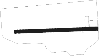
Runway info
| Runway 09 / 27 | ||
| length | 683m (2241ft) | |
| bearing | 92° / 272° | |
| width | 30m (100ft) | |
| surface | grass | |
| displ threshold | 0m (0ft) / 28m (92ft) | |
Nearby beacons
| code | identifier | dist | bearing | frequency |
|---|---|---|---|---|
| AUW | WAUSAU VOR/DME | 31.2 | 314° | 111.60 |
| AQ | KOOKY (APPLETON) NDB | 34.6 | 106° | 407 |
| OSH | OSHKOSH VORTAC | 36.7 | 127° | 116.75 |
| GR | FAMIS (GREEN BAY) NDB | 38.9 | 89° | 356 |
| GRB | GREEN BAY VORTAC | 41.5 | 83° | 115.50 |
| OS | POBER (OSHKOSH) NDB | 41.9 | 133° | 395 |
| DAF | NECEDAH NDB | 46.7 | 247° | 233 |
| DLL | DELLS (BARABOO) VORTAC | 59.1 | 215° | 117 |
Disclaimer
The information on this website is not for real aviation. Use this data with the X-Plane flight simulator only! Data taken with kind consent from X-Plane 12 source code and data files. Content is subject to change without notice.