Mengibar - Las Infantas
Airport details
| Country | Spain |
| State | Andalusia |
| Region | |
| Airspace | Madrid Ctr |
| Municipality | Jaén |
| Elevation | 1035ft (315m) |
| Timezone | GMT +1 |
| Coordinates | 37.90777, -3.80241 |
| Magnetic var | |
| Type | land |
| Available since | X-Plane v10.40 |
| ICAO code | XLE0017 |
| IATA code | n/a |
| FAA code | n/a |
Communication
Nearby Points of Interest:
Torre de María Martín
-Torre Olvidada
-El Brujuelo IV
-Torre del Cortijo de los Salineros
-Castillo del Berrueco
-Casa Fuerte
-Biblioteca Pública Provincial de Jaén
-City walls of Jaén
-Castillo de Peñaflor
-Arco de San Lorenzo
-Iglesia de San Ildefonso
-Torre del Sordo
-Torre Mocha
-Castillo de Ríez
-Cueva del Encajero
-Torreón de la Tercia
-Torre del Risquillo
-Hacienda La Laguna
-Molino del Cubo, Torredonjimeno
-Torre Benzalá
-Huerta de Pegalajar
-Casa Palacio del Vizconde de los Villares
-Mina-Fundición La Tortilla
-Torre del Homenaje del antiguo Castillo
-Muralla urbana de Martos
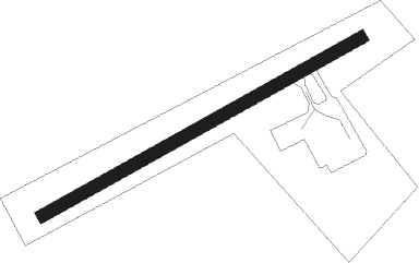
Runway info
| Runway 07 / 25 | ||
| length | 355m (1165ft) | |
| bearing | 70° / 250° | |
| width | 12m (41ft) | |
| surface | asphalt | |
Nearby beacons
| code | identifier | dist | bearing | frequency |
|---|---|---|---|---|
| BLN | BAILEN VOR/DME | 16.9 | 36° | 116.20 |
| GR | GRANADA OESTE NDB | 43.2 | 183° | 285 |
| GRA | GRANADA NDB | 43.5 | 170° | 412 |
| GDA | GRANADA VOR/DME | 44.4 | 195° | 113.40 |
| TGR | GRANADA TACAN | 47.2 | 168° | 113.10 |
Disclaimer
The information on this website is not for real aviation. Use this data with the X-Plane flight simulator only! Data taken with kind consent from X-Plane 12 source code and data files. Content is subject to change without notice.