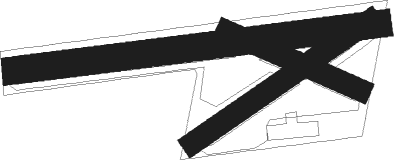
Courseulles-sur-mer - Courseulles Sur Mer
Airport details
| Country | France |
| State | Normandy |
| Region | |
| Airspace | Brest Ctr |
| Municipality | Courseulles-sur-Mer |
| Elevation | 148ft (45m) |
| Timezone | GMT +1 |
| Coordinates | 49.31343, -0.45452 |
| Magnetic var | |
| Type | land |
| Available since | X-Plane v11.40 |
| ICAO code | XLF002X |
| IATA code | n/a |
| FAA code | n/a |
Communication
| Courseulles sur Mer ATC Freq | 123.500 |
Nearby Points of Interest:
Pierre debout
-Chapelle Sainte-Christine de Reviers
-Château des Planches
-station radar de Douvres-la-Délivrande
-Pharmacie Lesage
-Plages du débarquement allié en Normandie
-Villa Bella Vista
-La Sapinière
-manoir du Manoir
-Station radar d'Arromanches-les-Bains
-Pierres Branlantes
-Croix du cimetière de Putot-en-Bessin
-Chapelle Saint-Vincent d'Hérouville-Saint-Clair
-Prison Beaulieu
-colombier de la Ferme du Mesnil
-10 rue Haldot, Caen
-Pavillon de Beuvrelu
-92 rue Bicoquet, Caen
-64 rue de Bayeux, Caen
-Villa Baumier
-10 rue Bicoquet, Caen
-Statue of Bertrand du Guesclin
-Hôtel de Colomby
-25 rue Saint-Martin, Caen
-Ancienne Visitation de Caen
Nearby beacons
| code | identifier | dist | bearing | frequency |
|---|---|---|---|---|
| CAN | CAEN CARPIQUET VOR/DME | 8.4 | 180° | 114.45 |
| CNE | CAEN NDB | 12.9 | 146° | 404 |
| DVL | DEAUVILLE NORMANDIE VOR | 30 | 90° | 110.20 |
| LHO | LE HAVRE NDB | 30.1 | 66° | 346 |
| MP | CHERBOURG NDB | 40.7 | 289° | 373 |
| LGL | L'AIGLE VOR/DME | 49.8 | 118° | 112.70 |
| EVX | EVREUX FAUVILLE VORTAC | 67.9 | 100° | 112.40 |
| ROU | ROUEN VALLEE DE SEINE VOR | 68.4 | 85° | 116.80 |
| DSA | DIEPPE NDB | 68.8 | 70° | 351 |
| DPE | DIEPPE VOR | 73.1 | 69° | 115.80 |
Disclaimer
The information on this website is not for real aviation. Use this data with the X-Plane flight simulator only! Data taken with kind consent from X-Plane 12 source code and data files. Content is subject to change without notice.

