Airports for X-Plane offers a convenient way to explore airports and their related communication information for the X-Plane flight simulator. It only uses data from the X-Plane flight simulator itself, and is therefore more reliable than the data that comes from real aviation websites. You can search for airports by using the ICAO code, or browse for airports per country and state. The information displayed is categorized by airport details, runway information, airport communication, approach frequencies (ILS and Glidepath details), details of nearby beacons, SIDs, STARs and approach procedures.

jet airliner flight local government passenger air safety aerodrome immigration jetliner airstrip non-towered airport arrival pilot international airport helicopters seaplanes hotel traffic airdock bus

Peniche - Atouguia Da Baleia

Airport details

CountryPortugal
StateAlto Viso
Region
AirspaceLisbon Ctr
MunicipalityPeniche
Elevation28ft (9m)
TimezoneGMT +0
Coordinates39.34917, -9.32003
Magnetic var
Typeland
Available sinceX-Plane v10.32
ICAO codeXLP0049
IATA coden/a
FAA coden/a

Communication

No airport communication available for XLP0049
Nearby Points of Interest:
Igreja matriz de Atouguia da Baleia
-
Fonte de Nossa Senhora da Conceição
-
Church of Nossa Senhora da Ajuda
-
Igreja matriz da Lourinhã
-
Igreja de São Sebastião
-
Óbidos halt
-
casa de cima - muralha do castelo de obidos
-
Palácio Gorjão
-
Chafariz das Cinco Bicas
-
Quinta dos Loridos
-
Padrão do Vimeiro
-
Igreja Paroquial de Alfeizerão
-
Church of Nossa Senhora da Vitória
-
Centro de Apoio Social de Runa
-
Igreja Paroquial de Runa
-
Capela de Nossa Senhora do Desterro
-
Termas da Piedade
-
Palácio de Pina Manique
-
Igreja matriz de São Silvestre do Gradil
-
Igreja de São Quintino
-
Túmulo de Damião de Góis
-
Fábrica Nova da Romeira
-
Chafariz de Arruda dos Vinhos
-
Palace of Mafra
-
Royal Building of Mafra

Runway info

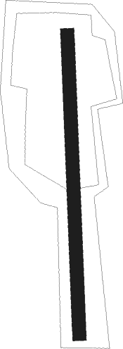
Runway 18 / 36
 length401m (1316ft)
 bearing183° / 3°
 width18m (59ft)
 surfacegrass

Airport layout


Nearby beacons

codeidentifierdistbearingfrequency
LARARRUDA (LISBON) NDB24.9142°382
STRSINTRA NDB28.3190°371
LISLISBON VOR/DME28.6161°114.80
SRASINTRA VORTAC31.2182°112.10
MTRMONTE REAL TACAN35.142°109.60
CASCASCAIS VOR/DME36.1184°114.30
MOJMONTIJO TACAN40.7156°110
FTMFATIMA VOR/DME42.769°113.50
ARRDME-ILS54157°108.30
ESPESPICHEL VOR/DME55.9172°112.50

Disclaimer

The information on this website is not for real aviation. Use this data with the X-Plane flight simulator only! Data taken with kind consent from X-Plane 12 source code and data files. Content is subject to change without notice.